
Fáìlì:Map of the Canary Islands.svg

Size of this PNG preview of this SVG file: 800 × 355 pixels. Àwọn ìgbéhàn míràn: 320 × 142 pixels | 640 × 284 pixels | 1,024 × 455 pixels | 1,280 × 569 pixels | 2,560 × 1,137 pixels | 3,152 × 1,400 pixels.
Fáìlì àtìbẹ̀rẹ̀ (faili SVG, pẹ̀lú 3,152 × 1,400 pixels, ìtòbi faili: 835 KB)
|
|
Fáìlì yìí wá láti Wikimedia Commons. Àròyé láti ojúewé ìjúwe rẹ̀ níbẹ̀ nìyí nísàlẹ̀. |
Àkótán
| Ìjúwe |
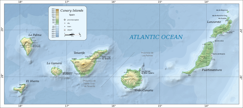
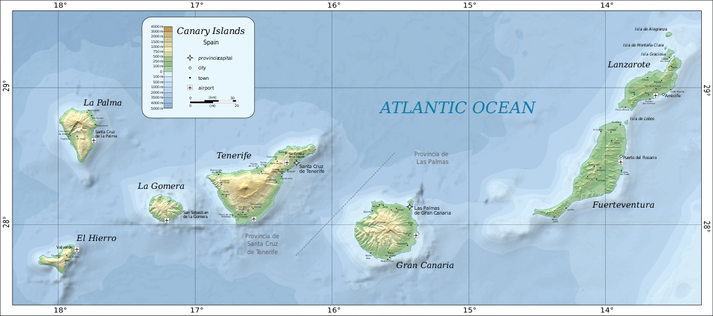
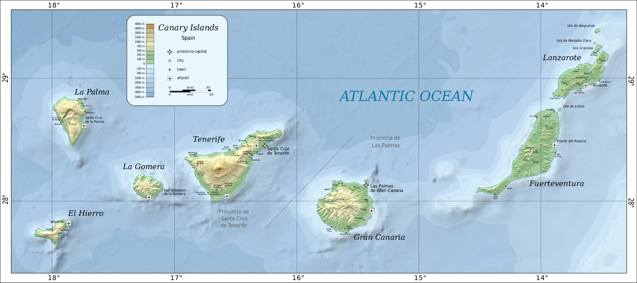
Deutsch: Karte der Kanarischen Inseln auf Englisch English: Map of the Canary Islands. Magyar: A Kanári-szigetek térképe Română: Harta Insulelor Canare. |
| Ọjọ́ọdún | |
| Orísun | Self-made in Inkscape by w:User:Mysid. Based on SRTM data as edited by CGIAR-CSI. Place names based on the Open Streetmap. |
| Olùdá | Oona Räisänen (Mysid) |
| Àwọn àtẹ̀jáde míràn |
|


Ìwé àṣẹ
| This work has been released into the public domain by its author, Mysid at Èdè Gẹ̀ẹ́sì Wikipédìà. This applies worldwide. In some countries this may not be legally possible; if so: Mysid grants anyone the right to use this work for any purpose, without any conditions, unless such conditions are required by law. |

|
This SVG file contains embedded text that can be translated into your language, using any capable SVG editor, text editor or the SVG Translate tool. For more information see: About translating SVG files. |
Ìtàn fáìlì
Ẹ kan kliki lórí ọjọ́ọdún/àkókò kan láti wo fáìlì ọ̀ún bó ṣe hàn ní àkókò na.
| Ọjọ́ọdún/Àkókò | Àwòrán kékeré | Àwọn ìwọ̀n | Oníṣe | Àríwí | |
|---|---|---|---|---|---|
| lọ́wọ́ | 14:57, 26 Oṣù Kẹfà 2020 | | 3,152 × 1,400 (835 KB) | Gaja | fixed and supplemented place names, some error correction |
| 23:31, 9 Oṣù Kẹjọ 2010 |  | 3,152 × 1,400 (828 KB) | Mysid | bathymetry experiment | |
| 17:00, 5 Oṣù Kẹjọ 2010 |  | 3,152 × 1,400 (736 KB) | Mysid | fonts | |
| 16:56, 5 Oṣù Kẹjọ 2010 |  | 3,152 × 1,400 (733 KB) | Mysid | updated with better data sources | |
| 21:49, 21 Oṣù Kínní 2009 |  | 776 × 399 (274 KB) | Mysid | revised fonts | |
| 20:59, 16 Oṣù Kínní 2009 |  | 776 × 399 (274 KB) | Mysid | resizing embedded png | |
| 13:13, 5 Oṣù Kínní 2009 |  | 776 × 399 (225 KB) | Mysid | major improvements | |
| 23:16, 1 Oṣù Kẹjọ 2007 |  | 734 × 355 (27 KB) | Mysid | {{Information |Description=Map of the Canary Islands. |Source=SVG drawn in Inkscape by Mysid; based on a JPEG (en:Image:Canary-map.jpg) originally compiled from a NASA source by Montrealais. |Date=August 2, 2007 |Author= [[w: |
Ìlò fáìlì
Ojúewé kan yìí únlo fáìlì yí:
Ìlò fáìlì káàkiri
Àwọn wiki míràn wọ̀nyí lo fáìlì yìí:
- Ìlò ní ar.wikipedia.org
- Ìlò ní ast.wikipedia.org
- Ìlò ní az.wikipedia.org
- Ìlò ní be-tarask.wikipedia.org
- Ìlò ní bg.wikipedia.org
- Ìlò ní bn.wikipedia.org
- Ìlò ní cs.wikipedia.org
- Ìlò ní da.wikipedia.org
- Ìlò ní de.wikipedia.org
- Ìlò ní de.wikivoyage.org
- Ìlò ní el.wikipedia.org
- Ìlò ní el.wikivoyage.org
- Ìlò ní en.wikipedia.org
- Ìlò ní es.wikipedia.org
- Ìlò ní eu.wikipedia.org
- Ìlò ní fi.wikipedia.org
- Ìlò ní fr.wikipedia.org
- Ìlò ní fy.wikipedia.org
- Ìlò ní id.wikipedia.org
- Ìlò ní is.wikipedia.org
- Ìlò ní it.wikivoyage.org
- Ìlò ní kbd.wikipedia.org
- Ìlò ní lb.wikipedia.org
- Ìlò ní lt.wikipedia.org
- Ìlò ní mn.wikipedia.org
- Ìlò ní nl.wikipedia.org
- Ìlò ní nn.wikipedia.org
- Ìlò ní no.wikipedia.org
- Ìlò ní pl.wikipedia.org
- Ìlò ní pl.wikivoyage.org
- Ìlò ní ru.wikipedia.org
- Ìlò ní sc.wikipedia.org
- Ìlò ní sv.wikivoyage.org
- Ìlò ní te.wikipedia.org
- Ìlò ní tt.wikipedia.org
- Ìlò ní uk.wikipedia.org
- Ìlò ní uk.wikivoyage.org
Ìfihàn ìlò míràn púpọ̀ fún fálì yìí.