
Fáìlì:Mauritius-CIA WFB Map.png
Kò sí ìgbéhàn gíga jù báun lọ.
Mauritius-CIA_WFB_Map.png (330 × 355 pixel, ìtóbi faili: 9 KB, irú MIME: image/png)
|
|
Fáìlì yìí wá láti Wikimedia Commons. Àròyé láti ojúewé ìjúwe rẹ̀ níbẹ̀ nìyí nísàlẹ̀. |
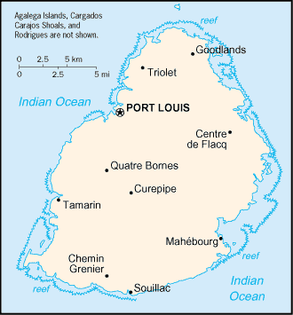
| Ìjúwe | Map of Mauritius showing towns. | |||
| Ọjọ́ọdún | ||||
| Orísun | CIA, The World Factbook, 2004 | |||
| Olùdá | CIA | |||
| Ìyọ̀nda (Ìtúnlò fáìlì yìí) |
|


|
This locator map image could be re-created using vector graphics as an SVG file. This has several advantages; see Commons:Media for cleanup for more information. If an SVG form of this image is available, please upload it and afterwards replace this template with
{{vector version available|new image name}}.
It is recommended to name the SVG file “Mauritius-CIA WFB Map.svg”—then the template Vector version available (or Vva) does not need the new image name parameter. |
Ìtàn fáìlì
Ẹ kan kliki lórí ọjọ́ọdún/àkókò kan láti wo fáìlì ọ̀ún bó ṣe hàn ní àkókò na.
| Ọjọ́ọdún/Àkókò | Àwòrán kékeré | Àwọn ìwọ̀n | Oníṣe | Àríwí | |
|---|---|---|---|---|---|
| lọ́wọ́ | 09:16, 27 Oṣù Kẹta 2005 | | 330 × 355 (9 KB) | Wolfman~commonswiki | {{CIA-map}} |
Ìlò fáìlì
Ojúewé kan yìí únlo fáìlì yí:
Ìlò fáìlì káàkiri
Àwọn wiki míràn wọ̀nyí lo fáìlì yìí:
- Ìlò ní als.wikipedia.org
- Ìlò ní arz.wikipedia.org
- Ìlò ní be-tarask.wikipedia.org
- Ìlò ní be.wikipedia.org
- Ìlò ní br.wikipedia.org
- Ìlò ní el.wikipedia.org
- Ìlò ní en.wikisource.org
- Ìlò ní eo.wikipedia.org
- Ìlò ní es.wikipedia.org
- Ìlò ní fi.wikipedia.org
- Ìlò ní fo.wikipedia.org
- Ìlò ní fy.wikipedia.org
- Ìlò ní gd.wikipedia.org
- Ìlò ní he.wikipedia.org
- Ìlò ní hr.wikipedia.org
- Ìlò ní ht.wikipedia.org
- Ìlò ní hu.wikipedia.org
- Ìlò ní hu.wiktionary.org
- Ìlò ní ia.wikipedia.org
- Ìlò ní id.wikipedia.org
- Ìlò ní io.wikipedia.org
- Ìlò ní ja.wikipedia.org
- Ìlò ní kn.wikipedia.org
- Ìlò ní la.wikipedia.org
- Ìlò ní lt.wikipedia.org
- Ìlò ní lt.wiktionary.org
- Ìlò ní mr.wikipedia.org
- Ìlò ní ms.wikipedia.org
- Ìlò ní nds-nl.wikipedia.org
- Ìlò ní ne.wikipedia.org
- Ìlò ní nl.wikipedia.org
- Ìlò ní nn.wikipedia.org
- Ìlò ní no.wikipedia.org
- Ìlò ní rue.wikipedia.org
- Ìlò ní ru.wikipedia.org
- Ìlò ní sg.wikipedia.org
- Ìlò ní sg.wiktionary.org
- Ìlò ní sh.wikipedia.org
- Ìlò ní sq.wikipedia.org
- Ìlò ní sr.wikipedia.org
- Ìlò ní sv.wikipedia.org
- Ìlò ní sw.wikipedia.org
Ìfihàn ìlò míràn púpọ̀ fún fálì yìí.