
Fáìlì:Newfoundland and Labrador-map.png
Kò sí ìgbéhàn gíga jù báun lọ.
Newfoundland_and_Labrador-map.png (280 × 230 pixel, ìtóbi faili: 14 KB, irú MIME: image/png)
|
|
Fáìlì yìí wá láti Wikimedia Commons. Àròyé láti ojúewé ìjúwe rẹ̀ níbẹ̀ nìyí nísàlẹ̀. |
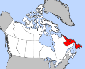
Map of Newfoundland and Labrador
Projection: Lambert azimuthal equal-area
Geospatial data from: The Atlas of Canada, The National Atlas of the United States and U.S. Geological Survey
Cartographer: John Fowler
| Èmi gangan, tó jẹ́ pé èmi ni mo ni ẹ̀tọ́àwòkọ iṣẹ́ yìí, jọ̀wọ́ ìṣẹ́ yìí sínú ìgboro. Èyí kan gbogbo ayé. In some countries this may not be legally possible; if so: I grant anyone the right to use this work for any purpose, without any conditions, unless such conditions are required by law. |
Ìtàn fáìlì
Ẹ kan kliki lórí ọjọ́ọdún/àkókò kan láti wo fáìlì ọ̀ún bó ṣe hàn ní àkókò na.
| Ọjọ́ọdún/Àkókò | Àwòrán kékeré | Àwọn ìwọ̀n | Oníṣe | Àríwí | |
|---|---|---|---|---|---|
| lọ́wọ́ | 12:15, 24 Oṣù Kẹta 2005 | | 280 × 230 (14 KB) | Voyager | Map of Newfoundland and Labrador Projection: Lambert azimuthal equal-area Geospatial data from: [http://atlas.gc.ca/ The Atlas of Canada], [http://www.nationalatlas.gov/ The National Atlas of the United States] and [http://www.usgs.gov U.S. Geological S |
Ìlò fáìlì
Ojúewé kan yìí únlo fáìlì yí:
Ìlò fáìlì káàkiri
Àwọn wiki míràn wọ̀nyí lo fáìlì yìí:
- Ìlò ní bat-smg.wikipedia.org
- Ìlò ní br.wikipedia.org
- Ìlò ní da.wikipedia.org
- Ìlò ní en.wikipedia.org
- Ìlò ní en.wikinews.org
- Ìlò ní en.wiktionary.org
- Ìlò ní eo.wikipedia.org
- Ìlò ní es.wikipedia.org
- Ìlò ní fo.wikipedia.org
- Ìlò ní frr.wikipedia.org
- Ìlò ní fr.wikinews.org
- Ìlò ní gd.wikipedia.org
- Ìlò ní hu.wikipedia.org
- Ìlò ní hu.wiktionary.org
- Ìlò ní hy.wikipedia.org
- Ìlò ní incubator.wikimedia.org
- Ìlò ní is.wikipedia.org
- Ìlò ní ja.wikipedia.org
- Ìlò ní kw.wikipedia.org
- Ìlò ní lij.wikipedia.org
- Ìlò ní mk.wikipedia.org
- Ìlò ní ms.wikipedia.org
- Ìlò ní nn.wikipedia.org
- Ìlò ní pam.wikipedia.org
- Ìlò ní pms.wikipedia.org
- Ìlò ní sc.wikipedia.org
- Ìlò ní ta.wikipedia.org
- Ìlò ní uk.wikipedia.org
- Ìlò ní vo.wikipedia.org
- Ìlò ní xmf.wikipedia.org
- Ìlò ní yi.wikipedia.org
- Ìlò ní zh-min-nan.wikipedia.org