
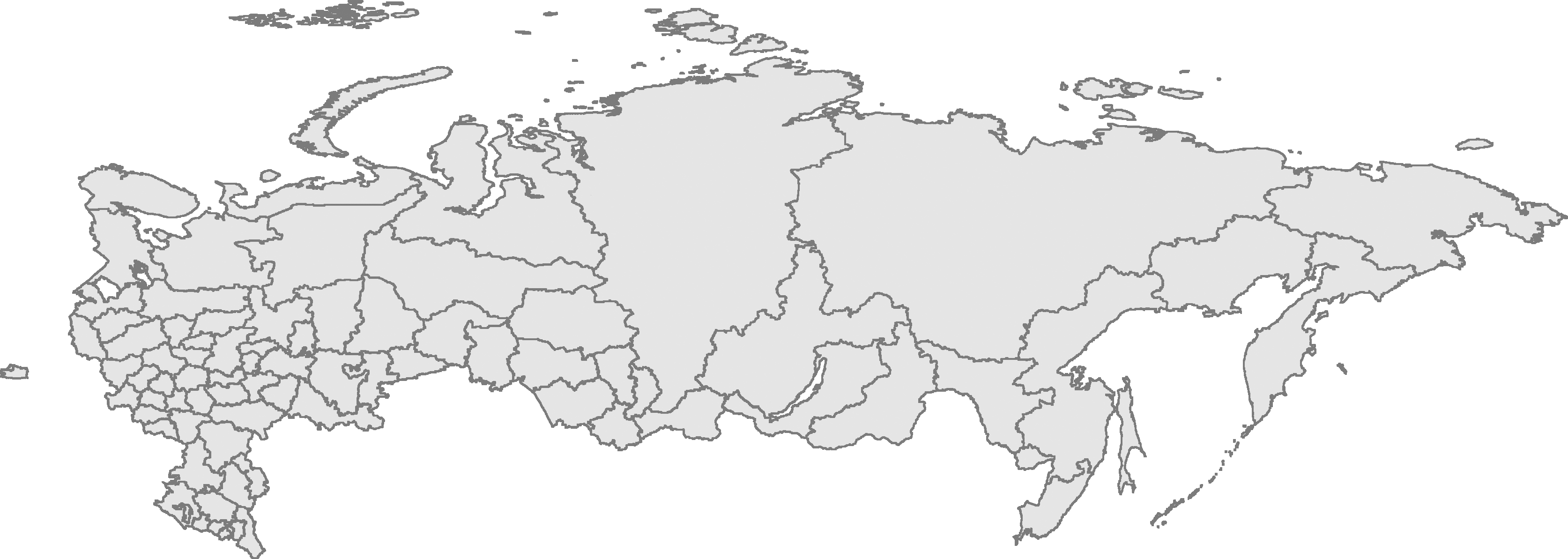
Fáìlì:RussiaContourMap.png
Ìtóbi ìkọ́yẹ̀wò yìí: 800 × 285 pixels. Àwọn ìgbéhàn míràn: 320 × 114 pixels | 640 × 228 pixels | 1,024 × 365 pixels | 1,280 × 456 pixels | 3,347 × 1,193 pixels.
Fáìlì àtìbẹ̀rẹ̀ (3,347 × 1,193 pixel, ìtóbi faili: 305 KB, irú MIME: image/png)
|
|
Fáìlì yìí wá láti Wikimedia Commons. Àròyé láti ojúewé ìjúwe rẹ̀ níbẹ̀ nìyí nísàlẹ̀. |
| Ìjúwe | Russian Federation contour map, based on Image:Russia-equirectang*1,5.png | ||
| Ọjọ́ọdún | |||
| Orísun | Iṣẹ́ onítọ̀hún | ||
| Olùdá | User:Kalan | ||
| Ìyọ̀nda (Ìtúnlò fáìlì yìí) |
|

|
This map image could be re-created using vector graphics as an SVG file. This has several advantages; see Commons:Media for cleanup for more information. If an SVG form of this image is available, please upload it and afterwards replace this template with
{{vector version available|new image name}}.
It is recommended to name the SVG file “RussiaContourMap.svg”—then the template Vector version available (or Vva) does not need the new image name parameter. |
Ìtàn fáìlì
Ẹ kan kliki lórí ọjọ́ọdún/àkókò kan láti wo fáìlì ọ̀ún bó ṣe hàn ní àkókò na.
| Ọjọ́ọdún/Àkókò | Àwòrán kékeré | Àwọn ìwọ̀n | Oníṣe | Àríwí | |
|---|---|---|---|---|---|
| lọ́wọ́ | 23:56, 10 Oṣù Kínní 2009 | 3,347 × 1,193 (305 KB) | Чръный человек | {{Information |Description= |Source= |Date= |Author= |Permission= |other_versions= }} | |
| 23:12, 29 Oṣù Kejì 2008 | 3,347 × 1,193 (95 KB) | Sasha Krotov | Забайкальский край | ||
| 17:01, 1 Oṣù Kínní 2008 | 3,347 × 1,193 (95 KB) | Sasha Krotov | Усть-Ордынский Бурятский автономный округ удалён | ||
| 16:38, 28 Oṣù Kejìlá 2007 | 3,347 × 1,193 (96 KB) | Sasha Krotov | Kamchatka fix | ||
| 20:28, 25 Oṣù Kẹrin 2007 | 3,347 × 1,193 (88 KB) | Obersachse | {{Information |Description=Russian Federation contour map, based on Image:Russia-equirectang*1,5.png |Source={{{source|Own work}}} |Date={{{date|17 03 2007}}} |Author=User:Kalan |Permission={{PD-self}} |other_versions={{{otherversio | ||
| 10:15, 23 Oṣù Kẹta 2007 | 6,694 × 2,387 (191 KB) | Kalan | map is now up to date; enhanced borders | ||
| 09:29, 17 Oṣù Kẹta 2007 | 6,694 × 2,387 (163 KB) | Kalan | {{subst:User:Kalan/Me-PD|description=Russian Federation contour map, based on Image:Russia-equirectang*1,5.png}} Category:Russia Category:Maps |
Ìlò fáìlì
Kò sí ojúewé tó únlo fáìlì yìí.
Ìlò fáìlì káàkiri
Àwọn wiki míràn wọ̀nyí lo fáìlì yìí:
- Ìlò ní ba.wikipedia.org
- Ìlò ní bg.wikipedia.org
- Ìlò ní de.wikipedia.org
- Ìlò ní en.wikisource.org
- Ìlò ní es.wikipedia.org
- Ìlò ní mk.wikipedia.org
- Ìlò ní nl.wikipedia.org
- Ìlò ní ro.wikipedia.org
- Ìlò ní ru.wikipedia.org
- Ìlò ní szl.wikipedia.org
- Kalińingrad
- Moskwa
- Uljanowsk
- Pejtersburg
- Kamyszin
- Murmańsk
- Władywostok
- Smoleńsk
- Kondopoga
- Taganrog
- Czelabińsk
- Puszkin (mjasto)
- Tambow
- Saratow
- Nieriungri
- Jekaterinburg
- Brjańsk
- Machaczkala
- Kazań
- Samara
- Ńiżńij Nowgorod
- Elista
- Ułan-Ude
- Ufa
- Gorno-Ałtajsk
- Nalczik
- Czerkesk
- Jakuck
- Kyzył
- Abakan
- Czeboksary
- Rostow na Donu
- Ńagań
- Iżewsk
- Soczi
- Jarosław (mjasto we Rusyji)
- Rossosz (Rusyjo)
Ìfihàn ìlò míràn púpọ̀ fún fálì yìí.