
Fáìlì:Somaliland map.png
Kò sí ìgbéhàn gíga jù báun lọ.
Somaliland_map.png (800 × 504 pixel, ìtóbi faili: 99 KB, irú MIME: image/png)
|
|
Fáìlì yìí wá láti Wikimedia Commons. Àròyé láti ojúewé ìjúwe rẹ̀ níbẹ̀ nìyí nísàlẹ̀. |
Àkótán
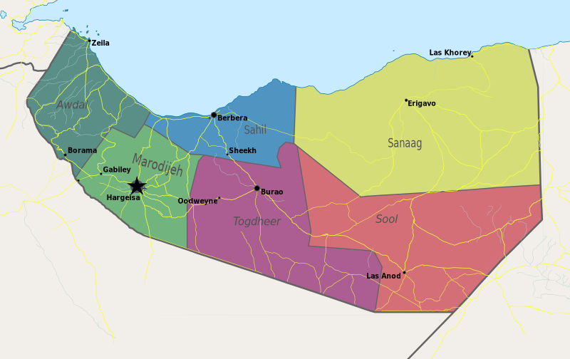
| Ìjúwe | Map of Somaliland. |
| Ọjọ́ọdún | |
| Orísun | Iṣẹ́ onítọ̀hún |
| Olùdá | PANONIAN |
Ìwé àṣẹ
Èmi gangan, tó jẹ́ pé èmi ni mo ni ẹ̀tọ́àwòkọ iṣẹ́ yìí, fara mọ́ ọ láti tẹ̀ẹ́jáde lábẹ́ ìwé-àṣẹ ìsàlẹ̀ yìí:
| This file is made available under the Creative Commons CC0 1.0 Universal Public Domain Dedication. | |
| The person who associated a work with this deed has dedicated the work to the public domain by waiving all of their rights to the work worldwide under copyright law, including all related and neighboring rights, to the extent allowed by law. You can copy, modify, distribute and perform the work, even for commercial purposes, all without asking permission.
|
References
- http://www.sdo.nu/wp-content/uploads/2010/04/map-vd-steden1.gif
- http://www.somaliland.org/images/i/map_somaliland_org.gif
- http://www.somaliland.org/images/b/2007/11/map_somaliland.gif
- http://images.wikia.com/turtledove/images/c/c7/SomalilandMap.jpg
- http://xarbi.files.wordpress.com/2010/11/somaliland-map-in-ai.jpg
- http://cdn-english.alshahid.net/wp-content/uploads/2010/02/somland.jpg?59dea9
- http://www.tothepointnews.com/images/stories/2011/somaliland_map.jpg
- http://xarbi.files.wordpress.com/2010/04/somaliland-map22.jpg
- http://xarbi.files.wordpress.com/2010/05/somaliland-map-20101.jpg
- http://www.afrol.com/images/maps/somaliland_big.gif
Ìtàn fáìlì
Ẹ kan kliki lórí ọjọ́ọdún/àkókò kan láti wo fáìlì ọ̀ún bó ṣe hàn ní àkókò na.
| Ọjọ́ọdún/Àkókò | Àwòrán kékeré | Àwọn ìwọ̀n | Oníṣe | Àríwí | |
|---|---|---|---|---|---|
| lọ́wọ́ | 11:55, 10 Oṣù Kàrún 2021 | | 800 × 504 (99 KB) | Siirski | Update |
| 18:04, 20 Oṣù Kẹfà 2020 |  | 1,254 × 741 (42 KB) | Chipmunkdavis | Reverted to version as of 14:41, 2 July 2012 (UTC) Rv unlablled change. The only labelled place is controlled by Somaliland. | |
| 20:31, 17 Oṣù Kẹfà 2020 |  | 800 × 473 (64 KB) | Meelpringthusss | clearer color | |
| 02:12, 16 Oṣù Kẹfà 2020 |  | 800 × 473 (64 KB) | Meelpringthusss | added disputed areas | |
| 14:41, 2 Oṣù Keje 2012 |  | 1,254 × 741 (42 KB) | PANONIAN | {{Information |Description=Map of Somaliland. |Source={{own}} |Date=2012 |Author= PANONIAN |Permission= |other_versions= }} |
Ìlò fáìlì
Kò sí ojúewé tó únlo fáìlì yìí.
Ìlò fáìlì káàkiri
Àwọn wiki míràn wọ̀nyí lo fáìlì yìí:
- Ìlò ní arz.wikipedia.org
- Ìlò ní be.wikipedia.org
- Ìlò ní bn.wikipedia.org
- Ìlò ní bs.wikipedia.org
- Ìlò ní ca.wikipedia.org
- Ìlò ní crh.wikipedia.org
- Ìlò ní dv.wikipedia.org
- Ìlò ní ga.wikipedia.org
- Ìlò ní hr.wikipedia.org
- Ìlò ní hy.wikipedia.org
- Ìlò ní incubator.wikimedia.org
- Ìlò ní ms.wikipedia.org
- Ìlò ní oc.wikipedia.org
- Ìlò ní pam.wikipedia.org
- Ìlò ní pnb.wikipedia.org
- Ìlò ní sa.wikipedia.org
- Ìlò ní sco.wikipedia.org
- Ìlò ní sh.wikipedia.org
- Ìlò ní sk.wikipedia.org
- Ìlò ní so.wikipedia.org
- Ìlò ní sr.wikipedia.org
- Ìlò ní su.wikipedia.org
- Ìlò ní ta.wikipedia.org
- Ìlò ní tl.wikipedia.org
- Ìlò ní tr.wikipedia.org
- Ìlò ní ur.wikipedia.org
- Ìlò ní xmf.wikipedia.org