
Fáìlì:UNsierraleone.PNG

Fáìlì àtìbẹ̀rẹ̀ (2,293 × 2,895 pixel, ìtóbi faili: 1.71 MB, irú MIME: image/png)
|
|
Fáìlì yìí wá láti Wikimedia Commons. Àròyé láti ojúewé ìjúwe rẹ̀ níbẹ̀ nìyí nísàlẹ̀. |
Àkótán
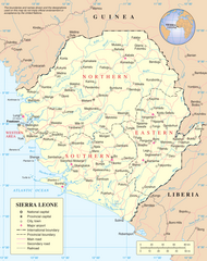
Map of Sierra Leone.
Source: http://www.un.org/Depts/Cartographic/map/profile/sierrale.pdf
| This image is a map derived from a United Nations map.
Unless stated otherwise, UN maps are to be considered in the public domain. This applies worldwide. UN maps are, in principle, open source material and you can use them in your work or for making your own map. UN requests however that you delete the UN name, logo and reference number upon any modification to the map. Content of your map will be your responsibility. You can state in your publication, if you wish, something like: based on UN map … (map name, map number, revision number and date). See: Geospatial Information Section. And: Geospatial, location data for a better world. |
 |
Ìtàn fáìlì
Ẹ kan kliki lórí ọjọ́ọdún/àkókò kan láti wo fáìlì ọ̀ún bó ṣe hàn ní àkókò na.
| Ọjọ́ọdún/Àkókò | Àwòrán kékeré | Àwọn ìwọ̀n | Oníṣe | Àríwí | |
|---|---|---|---|---|---|
| lọ́wọ́ | 14:04, 8 Oṣù Keje 2023 | | 2,293 × 2,895 (1.71 MB) | Lojwe | Cropped 2 % horizontally, 2 % vertically using CropTool with precise mode. |
| 02:11, 23 Oṣù Kẹ̀wá 2007 |  | 2,349 × 2,947 (1.7 MB) | Jeroen | Much higher resolution. | |
| 00:57, 9 Oṣù Kínní 2006 |  | 615 × 773 (176 KB) | Taichi | Map of Sierra Leone. Source: http://www.un.org/Depts/Cartographic/map/profile/sierrale.pdf {{PD-UN}} Category:Sierra Leone |
Ìlò fáìlì
Àwọn ojúewé 3 wọ̀nyí únlo fáìlì yí:
Ìlò fáìlì káàkiri
Àwọn wiki míràn wọ̀nyí lo fáìlì yìí:
- Ìlò ní ar.wikipedia.org
- Ìlò ní avk.wikipedia.org
- Ìlò ní azb.wikipedia.org
- Ìlò ní az.wikipedia.org
- Ìlò ní bg.wikipedia.org
- Ìlò ní bn.wikipedia.org
- Ìlò ní ca.wikipedia.org
- Sierra Leone
- Guerra Civil de Sierra Leone
- Resolució 1132 del Consell de Seguretat de les Nacions Unides
- Resolució 1270 del Consell de Seguretat de les Nacions Unides
- Resolució 1299 del Consell de Seguretat de les Nacions Unides
- Resolució 1400 del Consell de Seguretat de les Nacions Unides
- Resolució 1492 del Consell de Seguretat de les Nacions Unides
- Resolució 1508 del Consell de Seguretat de les Nacions Unides
- Resolució 1537 del Consell de Seguretat de les Nacions Unides
- Resolució 1610 del Consell de Seguretat de les Nacions Unides
- Missió de les Nacions Unides a Sierra Leone
- Resolució 1620 del Consell de Seguretat de les Nacions Unides
- Oficina Integral de les Nacions Unides a Sierra Leone
- Resolució 1829 del Consell de Seguretat de les Nacions Unides
- Oficina de les Nacions Unides per a la Consolidació de la Pau a Sierra Leone
- Resolució 1940 del Consell de Seguretat de les Nacions Unides
- Ìlò ní ckb.wikipedia.org
- Ìlò ní el.wikipedia.org
- Ìlò ní en.wikipedia.org
- Sierra Leone
- List of cities in Sierra Leone
- Operation Barras
- Outline of Sierra Leone
- Portal:Sierra Leone
- Portal:Sierra Leone/Selected picture
- United Nations Security Council Resolution 1132
- United Nations Security Council Resolution 1270
- United Nations Security Council Resolution 1688
- Mano, Sierra Leone
- Portal:Sierra Leone/Selected picture/6
- User:MarioGom/sandbox/Missing P21 German
- User:Northamerica1000/Topics
- Ìlò ní es.wikipedia.org
- Ìlò ní fa.wikipedia.org
- Ìlò ní fi.wikipedia.org
Ìfihàn ìlò míràn púpọ̀ fún fálì yìí.