
Fáìlì:Upper volta map with rivers.PNG
Ìtóbi ìkọ́yẹ̀wò yìí: 800 × 560 pixels. Àwọn ìgbéhàn míràn: 320 × 224 pixels | 640 × 448 pixels | 1,000 × 700 pixels.
Fáìlì àtìbẹ̀rẹ̀ (1,000 × 700 pixel, ìtóbi faili: 250 KB, irú MIME: image/png)
|
|
Fáìlì yìí wá láti Wikimedia Commons. Àròyé láti ojúewé ìjúwe rẹ̀ níbẹ̀ nìyí nísàlẹ̀. |
Àkótán
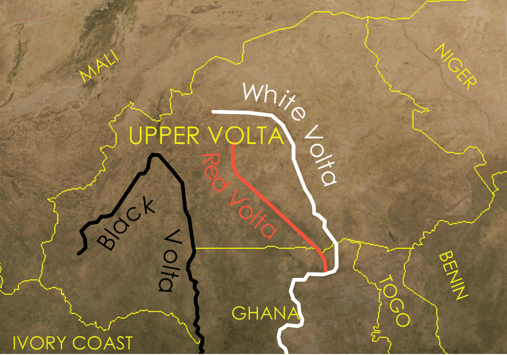
Map showing Upper volta and the red black and white volta rivers
The satellite image is a public domain image from NASA world wind, the other details were added on in Corel Painter IX.
Ìwé àṣẹ

|
Ìyọ̀nda wà láti ṣe àwòkọ, láti pínkàkiri àti/tàbí ṣ'àtúnse ìwé yìí l'ábẹ́ àwọn ọ̀rọ̀ àdéhùn GNU Free Documentation License, Version 1.2 tàbí ìtẹ̀jáde ọjọ́ọwájú lát'ọwọ́ Free Software Foundation; láìsí àwọn Ẹsẹ Aláìyàtọ̀, láìsí àwọn Ọ̀rọ̀-ìwé Níwájú, àti láìsí Ọ̀rọ̀-ìwé Lẹ́yìn. Àwòkọ ìwé àṣẹ náà jẹ́ sísopọ̀ mọ́ abala tí àkọlé rẹ̀ jẹ́ GNU Free Documentation License. |
| Fáìlì yìí wà lábẹ́ ìwé àṣẹ Creative Commons Ìdálórúkọ-Share Alike 3.0 Aláìkówọlé. | ||
| ||
| Àlẹ̀mọ́ ìwé àṣẹ yìí jẹ́ lílẹ̀mọ́ fáìlí yìí gẹ́gẹ́ bíi apá GFDL ìṣọdọ̀tun ìwé àṣẹ. |
Ìtàn fáìlì
Ẹ kan kliki lórí ọjọ́ọdún/àkókò kan láti wo fáìlì ọ̀ún bó ṣe hàn ní àkókò na.
| Ọjọ́ọdún/Àkókò | Àwòrán kékeré | Àwọn ìwọ̀n | Oníṣe | Àríwí | |
|---|---|---|---|---|---|
| lọ́wọ́ | 11:03, 28 Oṣù Kẹrin 2006 | | 1,000 × 700 (250 KB) | Roke~commonswiki | smaller file size |
| 11:00, 28 Oṣù Kẹrin 2006 |  | 1,000 × 700 (421 KB) | Roke~commonswiki | curved text, surrounding countries | |
| 05:26, 28 Oṣù Kẹrin 2006 |  | 1,000 × 697 (283 KB) | Roke~commonswiki | smaller file size | |
| 10:31, 23 Oṣù Kẹta 2006 |  | 1,000 × 697 (1.33 MB) | Roke~commonswiki | Map showing Upper volta and the red black and white volta rivers Category: Burkina Faso The satellite image is a public domain image from NASA world wind, the other details were added on in Corel Painter IX. |
Ìlò fáìlì
Ojúewé kan yìí únlo fáìlì yí:
Ìlò fáìlì káàkiri
Àwọn wiki míràn wọ̀nyí lo fáìlì yìí:
- Ìlò ní ar.wikipedia.org
- Ìlò ní azb.wikipedia.org
- Ìlò ní ca.wikipedia.org
- Ìlò ní da.wikipedia.org
- Ìlò ní en.wikipedia.org
- Ìlò ní he.wikipedia.org
- Ìlò ní hi.wikipedia.org
- Ìlò ní id.wikipedia.org
- Ìlò ní pt.wikipedia.org
- Ìlò ní ro.wikipedia.org
- Ìlò ní simple.wikipedia.org
- Ìlò ní sr.wikipedia.org
- Ìlò ní sw.wikipedia.org
- Ìlò ní vi.wikipedia.org