
Fáìlì:Agalega Islands map-en.svg

Size of this PNG preview of this SVG file: 493 × 600 pixels. Àwọn ìgbéhàn míràn: 197 × 240 pixels | 394 × 480 pixels | 631 × 768 pixels | 842 × 1,024 pixels | 1,683 × 2,048 pixels | 1,500 × 1,825 pixels.
Fáìlì àtìbẹ̀rẹ̀ (faili SVG, pẹ̀lú 1,500 × 1,825 pixels, ìtòbi faili: 434 KB)
|
|
Fáìlì yìí wá láti Wikimedia Commons. Àròyé láti ojúewé ìjúwe rẹ̀ níbẹ̀ nìyí nísàlẹ̀. |
Àkótán
| Camera location | | View this and other nearby images on: OpenStreetMap |
|---|
| Ìjúwe | |||
| Ọjọ́ọdún | |||
| Orísun |
Own work
|
||
| Olùdá | Eric Gaba (Sting - fr:Sting) | ||
| Ìyọ̀nda (Ìtúnlò fáìlì yìí) |
|
||
| Àwọn àtẹ̀jáde míràn |
|


|
This SVG file contains embedded text that can be translated into your language, using any capable SVG editor, text editor or the SVG Translate tool. For more information see: About translating SVG files. |
Ìwé àṣẹ
Èmi gangan, tó jẹ́ pé èmi ni mo ni ẹ̀tọ́àwòkọ iṣẹ́ yìí, fara mọ́ ọ láti tẹ̀ẹ́jáde lábẹ́ àwọn ìwé-àṣẹ ìsàlẹ̀ yìí:

|
Ìyọ̀nda wà láti ṣe àwòkọ, láti pínkàkiri àti/tàbí ṣ'àtúnse ìwé yìí l'ábẹ́ àwọn ọ̀rọ̀ àdéhùn GNU Free Documentation License, Version 1.2 tàbí ìtẹ̀jáde ọjọ́ọwájú lát'ọwọ́ Free Software Foundation; láìsí àwọn Ẹsẹ Aláìyàtọ̀, láìsí àwọn Ọ̀rọ̀-ìwé Níwájú, àti láìsí Ọ̀rọ̀-ìwé Lẹ́yìn. Àwòkọ ìwé àṣẹ náà jẹ́ sísopọ̀ mọ́ abala tí àkọlé rẹ̀ jẹ́ GNU Free Documentation License. |
This file is licensed under the Creative Commons Attribution-Share Alike 4.0 International, 3.0 Unported, 2.5 Generic, 2.0 Generic and 1.0 Generic license.
- Ẹ ní ààyè:
- láti pín pẹ̀lú ẹlòmíràn – láti ṣàwòkọ, pínkiri àti ṣàgbéká iṣẹ́ náà
- láti túndàpọ̀ – láti mulò mọ́ iṣẹ́ míràn
- Lábẹ́ àwọn àdéhùn wọ̀nyí:
- ìdárúkọ – Ẹ gbọdọ̀ ṣe ọ̀wọ̀ tó yẹ, pèsè ìjápọ̀ sí ìwé-àṣe, kí ẹ sì sọ bóyá ìyípadà wáyé. Ẹ le ṣe èyí lórísi ọ̀nà tó bojúmu, sùgbọ́n tí kò ní dà bii pé oníìwé-àṣe fọwọ́ sí yín tàbí lílò yín.
- share alike – Tó bá ṣe pé ẹ ṣ'àtúndàlú, ṣàyípadà, tàbí ṣ'àgbélé sí iṣẹ́-ọwọ́ náà, ẹ lè ṣe ìgbésíta àfikún yín lábẹ́ ìwé-àṣẹ kannáà tàbí tójọra mọ́ ti àtilẹ̀wa.
Ẹ le ṣàmúyàn ìwé-àṣẹ tí ó wù yín.
Ìtàn fáìlì
Ẹ kan kliki lórí ọjọ́ọdún/àkókò kan láti wo fáìlì ọ̀ún bó ṣe hàn ní àkókò na.
| Ọjọ́ọdún/Àkókò | Àwòrán kékeré | Àwọn ìwọ̀n | Oníṣe | Àríwí | |
|---|---|---|---|---|---|
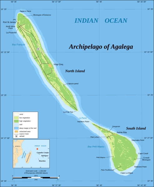
| lọ́wọ́ | 13:42, 30 Oṣù Kẹfà 2008 | | 1,500 × 1,825 (434 KB) | Sting | == Summary == {{Location|10|25|00|S|56|38|05|E|scale:200000}} <br/>{{Information |Description={{en|Map in English of the archipelago of Agalega, Mauritius.<br/> *UTM projection, WGS84 datum<br/> *Estimated scale : |
Ìlò fáìlì
Ojúewé kan yìí únlo fáìlì yí:
Ìlò fáìlì káàkiri
Àwọn wiki míràn wọ̀nyí lo fáìlì yìí:
- Ìlò ní cs.wikipedia.org
- Ìlò ní de.wikipedia.org
- Ìlò ní en.wikipedia.org
- Ìlò ní gl.wikipedia.org
- Ìlò ní it.wikipedia.org
- Ìlò ní ja.wikipedia.org
- Ìlò ní ka.wikipedia.org
- Ìlò ní ko.wikipedia.org
- Ìlò ní lt.wikipedia.org
- Ìlò ní nl.wikipedia.org
- Ìlò ní pl.wikipedia.org
- Ìlò ní ro.wikipedia.org
- Ìlò ní sv.wikipedia.org
- Ìlò ní ta.wikinews.org
- Ìlò ní tr.wikipedia.org
- Ìlò ní uk.wikipedia.org
- Ìlò ní www.wikidata.org
- Ìlò ní zh-yue.wikipedia.org
- Ìlò ní zh.wikipedia.org