
Fáìlì:Globe panorama03.jpg

Ìtóbi ìkọ́yẹ̀wò yìí: 800 × 533 pixels. Àwọn ìgbéhàn míràn: 320 × 213 pixels | 640 × 427 pixels | 1,024 × 683 pixels | 1,280 × 853 pixels | 2,560 × 1,707 pixels | 3,750 × 2,500 pixels.
Fáìlì àtìbẹ̀rẹ̀ (3,750 × 2,500 pixel, ìtóbi faili: 2.75 MB, irú MIME: image/jpeg)
|
|
Fáìlì yìí wá láti Wikimedia Commons. Àròyé láti ojúewé ìjúwe rẹ̀ níbẹ̀ nìyí nísàlẹ̀. |
|
Àkótán
| Ìjúwe |
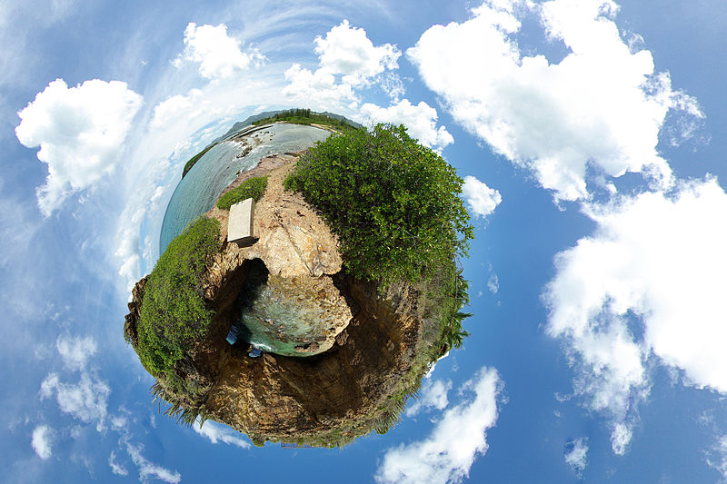
English: A 360-degree spherical panorama of a beach in Marigot, Saint Martin, from 9 images which uses stereographic projection to create a globe. This is called the "little planet" effect, when the area close to the point opposite to the center of projection becomes significantly enlarged. A detailed explanation of how it is done can be found here. This place is named Devil's Hole, located on the Low-lands area of the Saint Martin island (FWI) |
| Ọjọ́ọdún | |
| Orísun | Le trou de David |
| Olùdá | Alexandre Duret-Lutz from Paris, France |
| Àwọn àtẹ̀jáde míràn |
Derivative works of this file: Globe panorama03 (cropped).jpg |

.jpg)
| Camera location | | View this and other nearby images on: OpenStreetMap |
|---|
| 360° | View in 360° panoramic viewer
|
|---|
Ìwé àṣẹ
Fáìlì yìí wà lábẹ́ ìwé àṣẹ Creative Commons Ìdálórúkọ-Share Alike 2.0 Gbogbogbò.
- Ẹ ní ààyè:
- láti pín pẹ̀lú ẹlòmíràn – láti ṣàwòkọ, pínkiri àti ṣàgbéká iṣẹ́ náà
- láti túndàpọ̀ – láti mulò mọ́ iṣẹ́ míràn
- Lábẹ́ àwọn àdéhùn wọ̀nyí:
- ìdárúkọ – Ẹ gbọdọ̀ ṣe ọ̀wọ̀ tó yẹ, pèsè ìjápọ̀ sí ìwé-àṣe, kí ẹ sì sọ bóyá ìyípadà wáyé. Ẹ le ṣe èyí lórísi ọ̀nà tó bojúmu, sùgbọ́n tí kò ní dà bii pé oníìwé-àṣe fọwọ́ sí yín tàbí lílò yín.
- share alike – Tó bá ṣe pé ẹ ṣ'àtúndàlú, ṣàyípadà, tàbí ṣ'àgbélé sí iṣẹ́-ọwọ́ náà, ẹ lè ṣe ìgbésíta àfikún yín lábẹ́ ìwé-àṣẹ kannáà tàbí tójọra mọ́ ti àtilẹ̀wa.
| This image, originally posted to Flickr, was reviewed on 31 December 2007 by the administrator or reviewer RedCoat, who confirmed that it was available on Flickr under the stated license on that date. |
Ìtàn fáìlì
Ẹ kan kliki lórí ọjọ́ọdún/àkókò kan láti wo fáìlì ọ̀ún bó ṣe hàn ní àkókò na.
| Ọjọ́ọdún/Àkókò | Àwòrán kékeré | Àwọn ìwọ̀n | Oníṣe | Àríwí | |
|---|---|---|---|---|---|
| lọ́wọ́ | 11:21, 17 Oṣù Kọkànlá 2013 | | 3,750 × 2,500 (2.75 MB) | Denniss | Reverted to version as of 19:21, 31 December 2007 |
| 19:21, 31 Oṣù Kejìlá 2007 |  | 3,750 × 2,500 (2.75 MB) | File Upload Bot (Magnus Manske) | {{BotMoveToCommons|en.wikipedia}} {{Information |Description={{en|A 360 degree panorama projected into a spherical shape. Uploaded to [http://flickr.com/photo_zoom.gne?id=1188430515&context=set-72157594279945875&size=l flickr] by gadl. A detailed explant |
Ìlò fáìlì
Ojúewé kan yìí únlo fáìlì yí:
Ìlò fáìlì káàkiri
Àwọn wiki míràn wọ̀nyí lo fáìlì yìí:
- Ìlò ní ar.wikipedia.org
- Ìlò ní ast.wikipedia.org
- Ìlò ní ca.wikipedia.org
- Ìlò ní cs.wikipedia.org
- Ìlò ní de.wikipedia.org
- Ìlò ní el.wikipedia.org
- Ìlò ní en.wikipedia.org
- User talk:Abdominator
- User:Chutzpan
- User:Goa103~enwiki
- User:Virek
- Wikipedia:Featured pictures thumbs/09
- Wikipedia:April Fools' Main Page/Today's Featured Picture/Archive 2008
- Wikipedia:Featured picture candidates/January-2008
- Wikipedia:Featured picture candidates/Stereographic panorama
- Wikipedia:Wikipedia Signpost/2008-01-02/Features and admins
- Wikipedia:April Fools' Main Page/Today's Featured Picture/Archive 2009
- Wikipedia:Picture of the day/May 2008
- Template:POTD/2008-05-13
- Wikipedia:Reference desk/Archives/Science/2008 May 8
- Wikipedia:Wikipedia Signpost/2009-01-24/Dispatches
- Wikipedia talk:Wikipedia Signpost/2009-01-24/Dispatches
- Wikipedia:Featured pictures/Photographic techniques, terms, and equipment
- Portal:The arts/Recognized content
- Wikipedia:Wikipedia Signpost/Single/2008-01-02
- Ìlò ní es.wikipedia.org
- Super Mario Galaxy
- Wikipedia:Recurso del día/abril de 2008
- Wikipedia:Imágenes destacadas/Ciencias
- Wikipedia:Candidatos a recursos destacados/Globe panorama03.jpg
- Plantilla:RDD/118
- Wikipedia:Recurso del día/101 - 200
- Wikipedia:Recurso del día/febrero de 2009
- Wikipedia:Recurso del día/abril de 2010
- Usuario:SAVE THE World/Trabajos y contribuciones
- Wikipedia:Recurso del día/octubre de 2011
- Wikipedia:Recurso del día/octubre de 2013
- Portal:Biología/Imágenes/Archivo
- Portal:Biología/Imagen/Aleatorio/4
- Wikipedia:Recurso del día/abril de 2016
- Wikipedia:Recurso del día/julio de 2018
- Wikipedia:Recurso del día/noviembre de 2020
- Wikipedia:Recurso del día/octubre de 2023
- Ìlò ní fr.wikipedia.org
- Ìlò ní fr.wikibooks.org
- Ìlò ní id.wikipedia.org
- Ìlò ní is.wikipedia.org
- Ìlò ní ja.wikipedia.org
- Ìlò ní la.wikipedia.org
Ìfihàn ìlò míràn púpọ̀ fún fálì yìí.