
Fáìlì:Ladakh locator map.svg

Fáìlì àtìbẹ̀rẹ̀ (faili SVG, pẹ̀lú 2,160 × 1,696 pixels, ìtòbi faili: 202 KB)
|
|
Fáìlì yìí wá láti Wikimedia Commons. Àròyé láti ojúewé ìjúwe rẹ̀ níbẹ̀ nìyí nísàlẹ̀. |
| Àkólé |
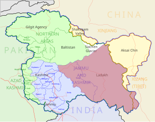
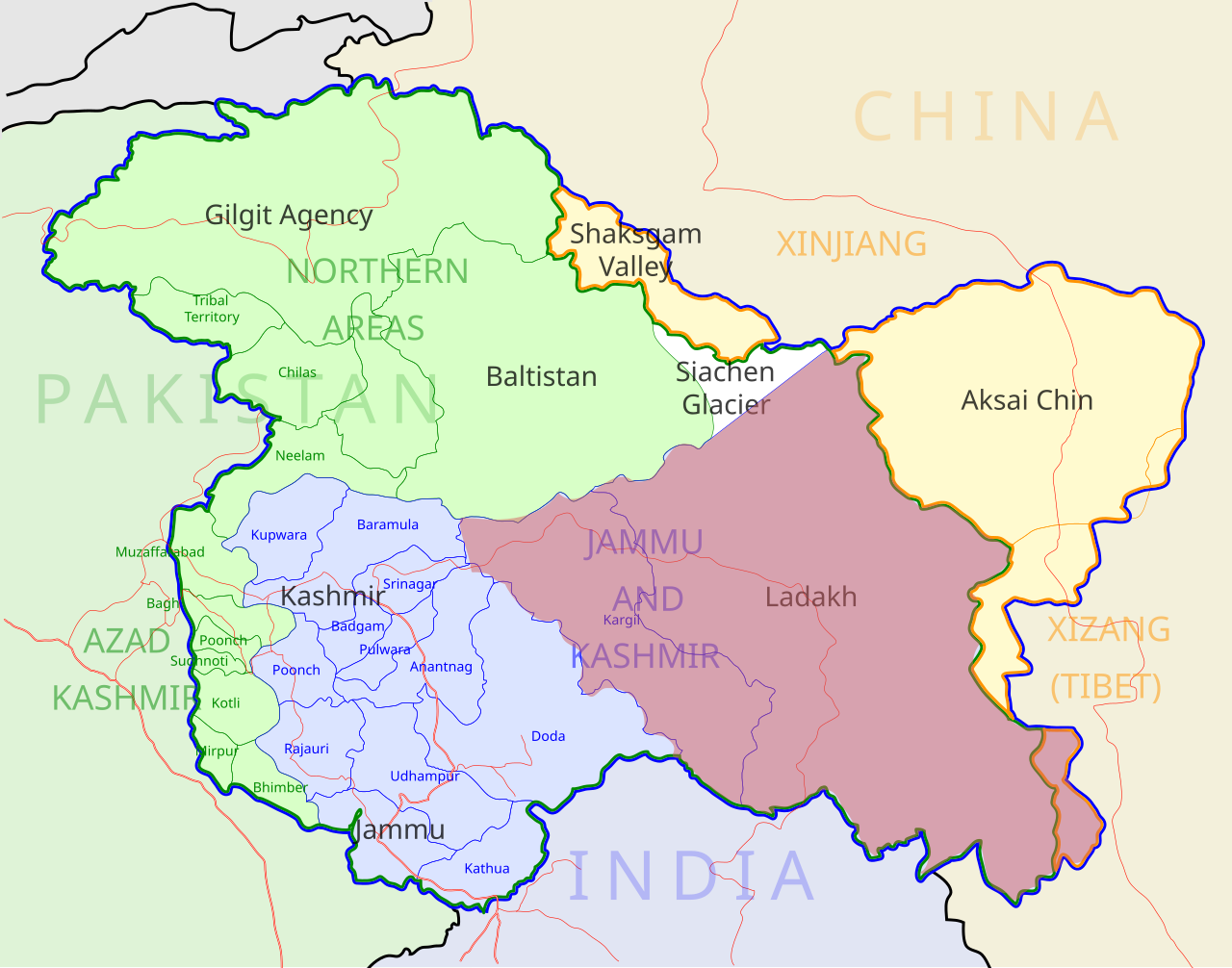
Ladakh locator map |
| Description |
Locator map for the region of w:Ladakh (higlighted in red) in the w:Indian state of w:Jammu and Kashmir |
| Ọjọ́ọdún | |
| Orísun |
Iṣẹ́ onítọ̀hún |
| Aṣèdá | |
| Ìyọ̀nda (Ìtúnlò fáìlì yìí) |
Èmi gangan, tó jẹ́ pé èmi ni mo ni ẹ̀tọ́àwòkọ iṣẹ́ yìí, fara mọ́ ọ láti tẹ̀ẹ́jáde lábẹ́ ìwé-àṣẹ ìsàlẹ̀ yìí: Fáìlì yìí wà lábẹ́ ìwé àṣẹ Creative Commons Ìdálórúkọ-Share Alike 3.0 Aláìkówọlé.
|
| Geotemporal data | |
| Date depicted | second half of 20 century àti 21 century |
| Georeferencing | If inappropriate please set warp_status = skip to hide. |
| Archival data | |
| Ìkíyèsí | Part of WikiProject India Maps |
Ìtàn fáìlì
Ẹ kan kliki lórí ọjọ́ọdún/àkókò kan láti wo fáìlì ọ̀ún bó ṣe hàn ní àkókò na.
| Ọjọ́ọdún/Àkókò | Àwòrán kékeré | Àwọn ìwọ̀n | Oníṣe | Àríwí | |
|---|---|---|---|---|---|
| lọ́wọ́ | 05:50, 2 Oṣù Kejìlá 2012 | | 2,160 × 1,696 (202 KB) | Baomi | 改“XIJANG”为“XIZANG” |
| 00:24, 10 Oṣù Kàrún 2007 |  | 2,160 × 1,696 (260 KB) | Saravask | {{WikiProject_India_Maps |Title=Ladakh locator map |Description=Locator map for the region of w:Ladakh (higlighted in red) in the w:Indian state of [w:Jammu and Kashmir]] |Source= [http://www.koausa.org/Nature/maps.html Map of Kashmir], |Date=May |
Ìlò fáìlì
Àwọn ojúewé 2 wọ̀nyí únlo fáìlì yí:
Ìlò fáìlì káàkiri
Àwọn wiki míràn wọ̀nyí lo fáìlì yìí:
- Ìlò ní as.wikipedia.org
- Ìlò ní awa.wikipedia.org
- Ìlò ní bpy.wikipedia.org
- Ìlò ní ceb.wikipedia.org
- Ìlò ní en.wikipedia.org
- Ìlò ní fa.wikipedia.org
- Ìlò ní he.wikipedia.org
- Ìlò ní hi.wikipedia.org
- Ìlò ní hu.wikipedia.org
- Ìlò ní incubator.wikimedia.org
- Ìlò ní it.wikipedia.org
- Ìlò ní it.wikivoyage.org
- Ìlò ní ja.wikipedia.org
- Ìlò ní ko.wikipedia.org
- Ìlò ní mai.wikipedia.org
- Ìlò ní ml.wikipedia.org
- Ìlò ní nn.wikipedia.org
- Ìlò ní no.wikipedia.org
- Ìlò ní or.wikipedia.org
- Ìlò ní pam.wikipedia.org
Ìfihàn ìlò míràn púpọ̀ fún fálì yìí.