
Fáìlì:Map of South Africa with Cacadu highlighted (2011).svg

Size of this PNG preview of this SVG file: 684 × 599 pixels. Àwọn ìgbéhàn míràn: 274 × 240 pixels | 548 × 480 pixels | 876 × 768 pixels | 1,168 × 1,024 pixels | 2,337 × 2,048 pixels | 809 × 709 pixels.
Fáìlì àtìbẹ̀rẹ̀ (faili SVG, pẹ̀lú 809 × 709 pixels, ìtòbi faili: 498 KB)
|
|
Fáìlì yìí wá láti Wikimedia Commons. Àròyé láti ojúewé ìjúwe rẹ̀ níbẹ̀ nìyí nísàlẹ̀. |
.svg)
Àkótán
| Ìjúwe |
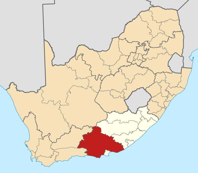
English: Map of district boundaries in South Africa, as they will be after the municipal elections of 18 May 2011, with the w:Cacadu District Municipality highlighted in red within the Eastern Cape in yellow. |
| Ọjọ́ọdún | |
| Orísun | Iṣẹ́ onítọ̀hún |
| Olùdá | Htonl |
Ìwé àṣẹ
Èmi gangan, tó jẹ́ pé èmi ni mo ni ẹ̀tọ́àwòkọ iṣẹ́ yìí, fara mọ́ ọ láti tẹ̀ẹ́jáde lábẹ́ àwọn ìwé-àṣẹ ìsàlẹ̀ yìí:

|
Ìyọ̀nda wà láti ṣe àwòkọ, láti pínkàkiri àti/tàbí ṣ'àtúnse ìwé yìí l'ábẹ́ àwọn ọ̀rọ̀ àdéhùn GNU Free Documentation License, Version 1.2 tàbí ìtẹ̀jáde ọjọ́ọwájú lát'ọwọ́ Free Software Foundation; láìsí àwọn Ẹsẹ Aláìyàtọ̀, láìsí àwọn Ọ̀rọ̀-ìwé Níwájú, àti láìsí Ọ̀rọ̀-ìwé Lẹ́yìn. Àwòkọ ìwé àṣẹ náà jẹ́ sísopọ̀ mọ́ abala tí àkọlé rẹ̀ jẹ́ GNU Free Documentation License. |
This file is licensed under the Creative Commons Attribution-Share Alike 4.0 International, 3.0 Unported, 2.5 Generic, 2.0 Generic and 1.0 Generic license.
- Ẹ ní ààyè:
- láti pín pẹ̀lú ẹlòmíràn – láti ṣàwòkọ, pínkiri àti ṣàgbéká iṣẹ́ náà
- láti túndàpọ̀ – láti mulò mọ́ iṣẹ́ míràn
- Lábẹ́ àwọn àdéhùn wọ̀nyí:
- ìdárúkọ – Ẹ gbọdọ̀ ṣe ọ̀wọ̀ tó yẹ, pèsè ìjápọ̀ sí ìwé-àṣe, kí ẹ sì sọ bóyá ìyípadà wáyé. Ẹ le ṣe èyí lórísi ọ̀nà tó bojúmu, sùgbọ́n tí kò ní dà bii pé oníìwé-àṣe fọwọ́ sí yín tàbí lílò yín.
- share alike – Tó bá ṣe pé ẹ ṣ'àtúndàlú, ṣàyípadà, tàbí ṣ'àgbélé sí iṣẹ́-ọwọ́ náà, ẹ lè ṣe ìgbésíta àfikún yín lábẹ́ ìwé-àṣẹ kannáà tàbí tójọra mọ́ ti àtilẹ̀wa.
Ẹ le ṣàmúyàn ìwé-àṣẹ tí ó wù yín.
Ìtàn fáìlì
Ẹ kan kliki lórí ọjọ́ọdún/àkókò kan láti wo fáìlì ọ̀ún bó ṣe hàn ní àkókò na.
| Ọjọ́ọdún/Àkókò | Àwòrán kékeré | Àwọn ìwọ̀n | Oníṣe | Àríwí | |
|---|---|---|---|---|---|
| lọ́wọ́ | 13:59, 2 Oṣù Kàrún 2011 | | 809 × 709 (498 KB) | Htonl | == Summary == {{Information |Description ={{en|1=Map of district boundaries in South Africa, as they will be after the municipal elections of 18 May 2011, with the w:Cacadu District Municipality highligh |
Ìlò fáìlì
Kò sí ojúewé tó únlo fáìlì yìí.
Ìlò fáìlì káàkiri
Àwọn wiki míràn wọ̀nyí lo fáìlì yìí:
- Ìlò ní af.wikipedia.org
- Nieu-Bethesda
- Grahamstad
- Bathurst, Oos-Kaap
- Port Alfred
- Graaff-Reinet
- Aberdeen, Oos-Kaap
- Adendorp
- Somerset-Oos
- Joubertina
- Boesmansriviermond
- Humansdorp
- Willowmore
- Pearston
- Riebeek-Oos
- Jansenville
- Steytlerville
- Hankey
- Patensie
- Kookhuis
- Jeffreysbaai
- Kareedouw
- Klipplaat
- Kirkwood
- Alicedale
- Kruisfontein
- Paterson
- Stormsrivier, Oos-Kaap
- Loerie
- Kendrew
- Kenton-on-Sea
- Alexandria, Oos-Kaap
- Stormsrivier
- Addo
- Louterwater
- Krakeelrivier (dorpie)
- Salem, Oos-Kaap
- St. Francisbaai
- Clarkson
- Thornham
- Coldstream
- Rietbron
- Misgund
- Tweeriviere
- Kaap St Francis
- Oesterbaai
- Sjabloonbespreking:Suid-Afrikaanse distriksmunisipaliteit navbox
- Cannon Rocks
- Boknesstrand
- Kasouga
- Thornhill, Kouga
Ìfihàn ìlò míràn púpọ̀ fún fálì yìí.
.svg)
.svg)