
Fáìlì:Sinai-peninsula-map.jpg

Ìtóbi ìkọ́yẹ̀wò yìí: 483 × 600 pixels. Àwọn ìgbéhàn míràn: 193 × 240 pixels | 387 × 480 pixels | 941 × 1,168 pixels.
Fáìlì àtìbẹ̀rẹ̀ (941 × 1,168 pixel, ìtóbi faili: 665 KB, irú MIME: image/jpeg)
|
|
Fáìlì yìí wá láti Wikimedia Commons. Àròyé láti ojúewé ìjúwe rẹ̀ níbẹ̀ nìyí nísàlẹ̀. |
فلسطين
Àkótán
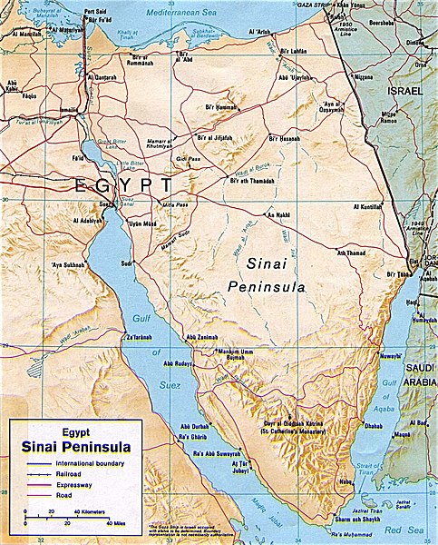
| Ìjúwe | Shaded relief map of the Sinai Peninsula, 1992, produced by the U.S. Central Intelligence Agency. |
| Ọjọ́ọdún | |
| Orísun | University of Texas Libraries, Perry-Castañeda Library Map Collection: Egypt Maps |
| Olùdá | CIA |
| Àwọn àtẹ̀jáde míràn |
|


Ìwé àṣẹ
| This image is a work of a Central Intelligence Agency employee, taken or made as part of that person's official duties. As a Work of the United States Government, this image or media is in the public domain in the United States.
|

|
Ìtàn fáìlì
Ẹ kan kliki lórí ọjọ́ọdún/àkókò kan láti wo fáìlì ọ̀ún bó ṣe hàn ní àkókò na.
| Ọjọ́ọdún/Àkókò | Àwòrán kékeré | Àwọn ìwọ̀n | Oníṣe | Àríwí | |
|---|---|---|---|---|---|
| lọ́wọ́ | 20:45, 12 Oṣù Kàrún 2011 | | 941 × 1,168 (665 KB) | Ras67 | cropped |
| 22:58, 4 Oṣù Kẹta 2007 |  | 956 × 1,196 (307 KB) | Joao Xavier | Map of the Sinai Peninsula. (U.S. Central Intelligence Agency, https://www.cia.gov/cia/publications/mapspub/index.shtml) originally found on University of Texas library website (http://www.lib.utexas.edu/maps/middle_east_and_asia/sinai.jpg) and claimed as |
Ìlò fáìlì
Ojúewé kan yìí únlo fáìlì yí:
Ìlò fáìlì káàkiri
Àwọn wiki míràn wọ̀nyí lo fáìlì yìí:
- Ìlò ní af.wikipedia.org
- Ìlò ní als.wikipedia.org
- Ìlò ní ar.wikipedia.org
- Ìlò ní ast.wikipedia.org
- Ìlò ní azb.wikipedia.org
- Ìlò ní az.wikipedia.org
- Ìlò ní az.wiktionary.org
- Ìlò ní ba.wikipedia.org
- Ìlò ní bn.wikipedia.org
- Ìlò ní bs.wikipedia.org
- Ìlò ní ca.wikipedia.org
- Ìlò ní cs.wikipedia.org
- Ìlò ní da.wikipedia.org
- Ìlò ní de.wikipedia.org
- Ìlò ní de.wikinews.org
- Ìlò ní de.wiktionary.org
- Ìlò ní diq.wikipedia.org
- Ìlò ní el.wikipedia.org
- Ìlò ní el.wiktionary.org
- Ìlò ní en.wikipedia.org
- Ìlò ní eo.wikipedia.org
- Ìlò ní es.wikipedia.org
- Ìlò ní eu.wikipedia.org
Ìfihàn ìlò míràn púpọ̀ fún fálì yìí.