
Fáìlì:Stop Digging ^ - geograph.org.uk - 195319.jpg
Kò sí ìgbéhàn gíga jù báun lọ.
Stop_Digging_^_-_geograph.org.uk_-_195319.jpg (561 × 429 pixel, ìtóbi faili: 75 KB, irú MIME: image/jpeg)
|
|
Fáìlì yìí wá láti Wikimedia Commons. Àròyé láti ojúewé ìjúwe rẹ̀ níbẹ̀ nìyí nísàlẹ̀. |
Àkótán
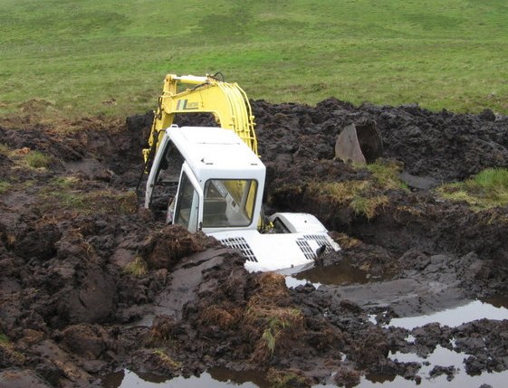
| Ìjúwe |
English: An excavator half-submerged in a large hole that it dug before falling in. A peat bog near Locherben, Dumfries and Galloway, Scotland. |
||||
| Ọjọ́ọdún | |||||
| Orísun | geograph.org.uk | ||||
| Olùdá | Chris Wimbush | ||||
| Ìyọ̀nda (Ìtúnlò fáìlì yìí) |
Fáìlì yìí wà lábẹ́ ìwé àṣẹ Creative Commons Ìdálórúkọ-Share Alike 2.0 Gbogbogbò. Ìdálórúkọ: Chris Wimbush
|
||||
| Ìdálórúkọ (required by the license) | Chris Wimbush / Stop Digging ? / | ||||

| Camera location | | View this and other nearby images on: OpenStreetMap |
|---|
_heading:90.00&language=yo)
| Object location | | View this and other nearby images on: OpenStreetMap |
|---|
_heading:90.00&language=yo)
Ìtàn fáìlì
Ẹ kan kliki lórí ọjọ́ọdún/àkókò kan láti wo fáìlì ọ̀ún bó ṣe hàn ní àkókò na.
| Ọjọ́ọdún/Àkókò | Àwòrán kékeré | Àwọn ìwọ̀n | Oníṣe | Àríwí | |
|---|---|---|---|---|---|
| lọ́wọ́ | 21:10, 14 Oṣù Kejìlá 2016 | | 561 × 429 (75 KB) | EEng | crop |
| 18:49, 31 Oṣù Kínní 2010 |  | 640 × 480 (98 KB) | GeographBot | == {{int:filedesc}} == {{Information |description={{en|1=Stop Digging ? A possible permanent landmark unless it sinks out of sight into the peat}} |date=2006-07-01 |source=From [http://www.geograph.org.uk/photo/195319 geograph.org.uk] |author=[http://www. |
Ìlò fáìlì
Ojúewé kan yìí únlo fáìlì yí:
Ìlò fáìlì káàkiri
Àwọn wiki míràn wọ̀nyí lo fáìlì yìí:
- Ìlò ní en.wikipedia.org
- Ìlò ní fa.wikipedia.org
- Ìlò ní fr.wikipedia.org
- Ìlò ní www.wikidata.org