
Fáìlì:Wtc-photo.jpg

Ìtóbi ìkọ́yẹ̀wò yìí: 600 × 600 pixels. Àwọn ìgbéhàn míràn: 240 × 240 pixels | 480 × 480 pixels | 768 × 768 pixels | 1,024 × 1,024 pixels | 2,048 × 2,048 pixels | 9,372 × 9,372 pixels.
Fáìlì àtìbẹ̀rẹ̀ (9,372 × 9,372 pixel, ìtóbi faili: 14.03 MB, irú MIME: image/jpeg)
|
|
Fáìlì yìí wá láti Wikimedia Commons. Àròyé láti ojúewé ìjúwe rẹ̀ níbẹ̀ nìyí nísàlẹ̀. |
| Warning | The original file is very high-resolution. It might not load properly or could cause your browser to freeze when opened at full size. |
|---|
|
Àkótán
| Ìjúwe |
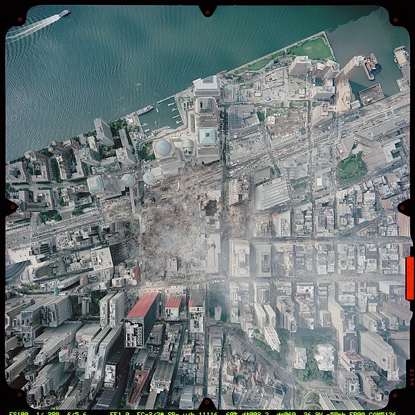
العربية: حطام مجمع مركز التجارة العالمي في وسط مدينة نيويورك بالولايات المتحدة، عقب أحداث 11 سبتمبر 2001. صورة ملتقطة بعدسة طائرة من طراز سيسنا ستيشن جيت التابعة للإدارة الوطنية للمحيطات والغلاف الجوي بتاريخ 23 سبتمبر عام 2001 من على ارتفاع 3,300 قدم (1,005 متر) باستخدام منظومتي Leica/LH systems بكاميرا RC30.
English: Remains of the World Trade Center complex in downtown New York City, United States, after the September 11 attacks. Image taken by NOAA's Cessna CitationJet on September 23, 2001, from an altitude of 3,300 ft (1,005 m) using a Leica/LH systems RC30 camera.
Español: Las ruinas del World Trade Center en el centro de Nueva York, Estados Unidos, después de los atentados del 11 de septiembre de 2001. Fotografó por NOAA de su avión Cessna 525 CitationJet del 23 de septiembre de 2001, a una altitud de 3,300 ft (1,005 m) con una camára Leica/LH Systems RC30. |
| Ọjọ́ọdún | Taken on 23 Oṣù Kẹ̀sán 2001 |
| Orísun | http://www.noaanews.noaa.gov/wtc/images/wtc-photo.jpg NOAA photo from http://www.noaanews.noaa.gov/stories/s798b.htm |
| Olùdá | National Oceanic and Atmospheric Administration (NOAA) |
| Àwọn àtẹ̀jáde míràn |
Cropped versions: File:Aerial photo of WTC groundzero.jpg , File:4-Wtc-photo.jpg, File:5-wtc-photo.jpg, File:6-wtc-photo.jpg, File:Wtc-photo (cropped 7WTC).jpg
|


.jpg)


| Camera location | | View this and other nearby images on: OpenStreetMap |
|---|
| Open this image as an overlay in Google Earth (Google Maps, Bing) | (Help|Source) |
Ìwé àṣẹ
This image is in the public domain because it contains materials that originally came from the U.S. National Oceanic and Atmospheric Administration, taken or made as part of an employee's official duties.
|
Ìtàn fáìlì
Ẹ kan kliki lórí ọjọ́ọdún/àkókò kan láti wo fáìlì ọ̀ún bó ṣe hàn ní àkókò na.
| Ọjọ́ọdún/Àkókò | Àwòrán kékeré | Àwọn ìwọ̀n | Oníṣe | Àríwí | |
|---|---|---|---|---|---|
| lọ́wọ́ | 18:22, 6 Oṣù Kejìlá 2006 | | 9,372 × 9,372 (14.03 MB) | Trevor MacInnis | {{Information |Description= |Source=http://www.noaanews.noaa.gov/wtc/images/wtc-photo.jpg |Date=December 6, 2006 |Author= |Permission= |other_versions= }} |
Ìlò fáìlì
Àwọn ojúewé 2 wọ̀nyí únlo fáìlì yí:
Ìlò fáìlì káàkiri
Àwọn wiki míràn wọ̀nyí lo fáìlì yìí:
- Ìlò ní ar.wikipedia.org
- هجمات 11 سبتمبر
- ويكيبيديا:صور مختارة/تاريخ وأحداث/أحداث معاصرة
- ويكيبيديا:ترشيحات الصور المختارة/صورة جوية لمنهاتن عام 2001
- ويكيبيديا:صورة اليوم المختارة/أكتوبر 2018
- قالب:صورة اليوم المختارة/2018-10-14
- ويكيبيديا:صورة اليوم المختارة/سبتمبر 2022
- قالب:صورة اليوم المختارة/2022-09-18
- موقع مركز التجارة العالمي
- Ìlò ní bcl.wikipedia.org
- Ìlò ní bg.wikipedia.org
- Ìlò ní bh.wikipedia.org
- Ìlò ní cs.wikipedia.org
- Ìlò ní de.wikipedia.org
- Ìlò ní el.wikipedia.org
- Ìlò ní en.wikipedia.org
- World Trade Center site
- Hypocenter
- History of New York City (1978–present)
- Portal:New York City
- User:Trevor MacInnis/Articles
- Wikipedia:Featured pictures thumbs/08
- Wikipedia:Featured picture candidates/September-2007
- Wikipedia:Featured picture candidates/WTC (23 September 2001)
- Wikipedia:Wikipedia Signpost/2007-10-01/Features and admins
- Wikipedia:Picture of the day/January 2008
- Template:POTD/2008-01-21
- Wikipedia:Featured pictures/History/USA History
- Wikipedia:Wikipedia Signpost/2007-10-01/SPV
- User:Cs32en/911/Overview/Sources/images
- Wikipedia:WikiProject United States/Recognized content
- Wikipedia:WikiProject United States/Quality content
- Wikipedia:WikiProject United States/Featured pictures
- Wikipedia:Wikipedia Signpost/Single/2007-10-01
- Ìlò ní en.wikiquote.org
- Ìlò ní eo.wikipedia.org
- Ìlò ní fa.wikipedia.org
- Ìlò ní fi.wikipedia.org
- Ìlò ní fr.wikipedia.org
- Ìlò ní he.wikipedia.org
- Ìlò ní id.wikipedia.org
- Ìlò ní it.wikipedia.org
- Ìlò ní ms.wikipedia.org
Ìfihàn ìlò míràn púpọ̀ fún fálì yìí.