
Fáìlì:Africa map regions.svg

Size of this PNG preview of this SVG file: 585 × 600 pixels. Àwọn ìgbéhàn míràn: 234 × 240 pixels | 468 × 480 pixels | 749 × 768 pixels | 999 × 1,024 pixels | 1,998 × 2,048 pixels | 1,200 × 1,230 pixels.
Fáìlì àtìbẹ̀rẹ̀ (faili SVG, pẹ̀lú 1,200 × 1,230 pixels, ìtòbi faili: 96 KB)
|
|
Fáìlì yìí wá láti Wikimedia Commons. Àròyé láti ojúewé ìjúwe rẹ̀ níbẹ̀ nìyí nísàlẹ̀. |
Àkótán
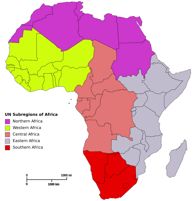
| Ìjúwe | Based on Image:Blank_Map-Africa.svg by User:Andreas 06 |
| Ọjọ́ọdún | 14 Oṣù Kejì 2007 (original upload date) |
| Orísun | No machine-readable source provided. Own work assumed (based on copyright claims). |
| Olùdá | No machine-readable author provided. Mvc assumed (based on copyright claims). |
Ìwé àṣẹ
| Èmi gangan, tó jẹ́ pé èmi ni mo ni ẹ̀tọ́àwòkọ iṣẹ́ yìí, jọ̀wọ́ ìṣẹ́ yìí sínú ìgboro. Èyí kan gbogbo ayé. In some countries this may not be legally possible; if so: I grant anyone the right to use this work for any purpose, without any conditions, unless such conditions are required by law. |
Ìtàn fáìlì
Ẹ kan kliki lórí ọjọ́ọdún/àkókò kan láti wo fáìlì ọ̀ún bó ṣe hàn ní àkókò na.
| Ọjọ́ọdún/Àkókò | Àwòrán kékeré | Àwọn ìwọ̀n | Oníṣe | Àríwí | |
|---|---|---|---|---|---|
| lọ́wọ́ | 12:36, 17 Oṣù Kàrún 2023 | | 1,200 × 1,230 (96 KB) | Illchy | File uploaded using svgtranslate tool (https://svgtranslate.toolforge.org/). Added translation for id. |
| 12:52, 9 Oṣù Kẹta 2015 |  | 1,200 × 1,230 (91 KB) | LukeSurl | Update, splitting Sudan into Sudan (Northern Africa) and Southern Sudan (Eastern Africa). (Actually uploading the new version this time) | |
| 12:50, 9 Oṣù Kẹta 2015 |  | 1,200 × 1,230 (91 KB) | LukeSurl | Update, splitting Sudan into Sudan (Northern Africa) and Southern Sudan (Eastern Africa). | |
| 20:42, 14 Oṣù Kejì 2007 |  | 1,200 × 1,230 (91 KB) | Mvc | Based on Image:Blank_Map-Africa.svg by User:Andreas 06 |
Ìlò fáìlì
Ojúewé kan yìí únlo fáìlì yí:
Ìlò fáìlì káàkiri
Àwọn wiki míràn wọ̀nyí lo fáìlì yìí:
- Ìlò ní ar.wikipedia.org
- Ìlò ní cv.wikipedia.org
- Ìlò ní en.wikipedia.org
- Ìlò ní es.wikipedia.org
- Ìlò ní es.wikibooks.org
- Ìlò ní eu.wikipedia.org
- Ìlò ní fa.wikipedia.org
- Ìlò ní fi.wikipedia.org
- Ìlò ní gl.wikipedia.org
- Ìlò ní ha.wikipedia.org
- Ìlò ní id.wikipedia.org
- Ìlò ní lt.wikipedia.org
- Ìlò ní ms.wikipedia.org
- Ìlò ní om.wikipedia.org
- Ìlò ní pt.wikipedia.org
- Ìlò ní ru.wikipedia.org
- Ìlò ní rw.wikipedia.org
- Ìlò ní sl.wiktionary.org
- Ìlò ní sv.wikipedia.org
- Ìlò ní uk.wiktionary.org
- Ìlò ní zh.wikipedia.org