
Fáìlì:Alluvial fan, Taklimakan Desert, XinJiang Province, China, NASA, ASTER.jpg

Ìtóbi ìkọ́yẹ̀wò yìí: 554 × 600 pixels. Àwọn ìgbéhàn míràn: 222 × 240 pixels | 443 × 480 pixels | 709 × 768 pixels | 946 × 1,024 pixels | 1,892 × 2,048 pixels | 3,774 × 4,086 pixels.
Fáìlì àtìbẹ̀rẹ̀ (3,774 × 4,086 pixel, ìtóbi faili: 3.48 MB, irú MIME: image/jpeg)
|
|
Fáìlì yìí wá láti Wikimedia Commons. Àròyé láti ojúewé ìjúwe rẹ̀ níbẹ̀ nìyí nísàlẹ̀. |
|

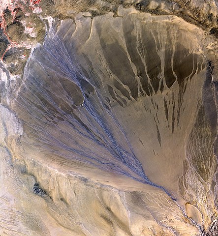
This image was selected as picture of the day on Wikimedia Commons for 19 June 2010. It was captioned as follows: English: A vast alluvial fan blossoms across the desolate landscape between the Kunlun and Altun mountain ranges that form the southern border of the Taklimakan Desert in China’s XinJiang Province. The left side is the active part of the fan, and appears blue from water currently flowing in the many small streams. The image was acquired May 2, 2002, covers an area of 56.6 × 61.3 km, and is centered near 37.4 degrees north, 84.3 degrees east. Other languages:
Čeština: Rozsáhlý náplavový kužel prostírájící se v pustinách při jihovýchodním okraji pouště Taklamakan, na pomezí pohoří Kchun-lun a Altyn-tagh v ujgurské autonomní oblasti Sin-ťiang na severozápadě ČLR. Patrná je aktivní levá strana kužele s modravými rozvodněnými říčkami, napájenými tajícím jarním sněhem z hor. Snímek byl pořízen 2. května 2005 a zachycuje oblast o rozměrech 56,6 × 61,3 km se středem poblíž 37° 24' s. š. a 84° 18' v. d. Dansk: Et stor vifteformet aflejring i det øde landskab mellem Kunlun- og Altun-bjergene, som danner den sydlige grænse for Taklimakanørkenen i Kinas Xinjiang-provins. Venstre side er den aktive del og har blå farve fra vand, der løber i mange små strømme. Billedet dækker et areal på 56,6 × 61,3 km og har centrum i 37,4 grader nord, 84,3 grader øst. Deutsch: Ein ausgedehnter Schwemmkegel erstreckt sich über das Ödland zwischen den Kunlun- und Altun-Bergketten, die den südlichen Rand der Wüste Taklamakan bilden. Eine Aufnahme des Advanced Spaceborne Thermal Emission and Reflection Radiometer an Bord des Erdbeobachtungssatelliten Terra. English: A vast alluvial fan blossoms across the desolate landscape between the Kunlun and Altun mountain ranges that form the southern border of the Taklimakan Desert in China’s XinJiang Province. The left side is the active part of the fan, and appears blue from water currently flowing in the many small streams. The image was acquired May 2, 2002, covers an area of 56.6 × 61.3 km, and is centered near 37.4 degrees north, 84.3 degrees east. Español: Un gran cono de deyección en el desierto próximo a la cadena montañosa de Altun y del Kunlun, que constituye el límite meridional de la cuenca hidrográfica del Tarim, en la región china de Xinjiang. La parte activa del cono aparece coloreada en azul por la presencia de agua corriente. Français : Vaste cône de déjection alluvial dans une région désertique entre les monts Kunlun et Altoun, qui forment la limite sud du désert du Taklamakan, dans la province chinoise du Xinjiang. La partie active du delta se trouve à gauche, où les nombreux petits cours d'eau la font apparaître en bleu. Cette photographie a été prise le 2 mai 2002, et couvre une superficie de 56,6 sur 61,3 km. Son centre se trouve vers 37,4° nord et 84,3° est. Italiano: Un vasto conoide di deiezione si apre a ventaglio nell'area desertica prossimale alle catene montuose dell'Altun e del Kunlun che costituiscono il confine meridionale del bacino idrografico del Tarim nella regione autonoma cinese dello Xinjiang. La parte attiva del reticolo idrografico del conoide appare colorata di blu per la presenza delle acque correnti Nederlands: Een uitgestrekte puinwaaier doorsnijdt het verlaten landschap tussen de bergketens Kunlun en Altun (Altyn-Tagh) die de zuidelijke grens van de Taklamakanwoestijn in de Chinese provincie Sinkiang (Xinjiang). De linkerzijde vormt het actieve deel van de waaier en licht blauw op door het water dat er vertakt over vele kleine stroompjes overheen stroomt. De afbeelding werd genomen in 2002 en omvat een gebied van ongeveer 60 bij 60 kilometer. Svenska: En alluvialkon mellan bergskedjorna Kunlun och Altun som ligger vid den södra kanten av Taklamakanöknen i Kina. Tiếng Việt: Quạt bồi tích đang nở băng qua vùng đất hoang giữa hai rặng núi Kunlun và Altun hình thành nên biên giới phía nam của Sa mạc của tỉnh Tân Cương, Trung Quốc. Phía bên trái là phần còn hoạt động của tấm quạt, có màu xanh hình thành từ dòng nước chảy theo nhiều nhánh. Hình được chụp vào ngày 2 tháng 5 năm 2002, trên diện tích là 56,6 × 61,3 km, và ở vị trí gần 37,4 độ bắc, 84,3 độ đông. Македонски: Огромен наносен конус помеѓу планините Кунлун и Алатун (Кина). На север од нив се протега пустината Такла Макан. 한국어: 신장 위구르 자치구의 타클리마칸 사막 남쪽을 가로지르는 쿤룬 산맥과 알툰 산맥 사이의 선상지. 왼쪽에는 물이 흐르고 있어서 푸른색으로 보인다. 북위 37.4도 동경 84.3도 근처이며, 56.6 × 61.3 km 크기의 영역이다. 2002년 5월 2일 촬영. 日本語: タクラマカン砂漠(中国・新疆ウイグル自治区)南部、崑崙山脈と阿爾金山脈に挟まれた地方に見られる巨大な扇状地。「扇」の左側には川が幾筋にも分かれて流れているのが見える。2002年5月2日撮影。北緯37度24分東経84度18分を中心とした56.6km×61.3kmの範囲を示す。 |
Àkótán
| Ìjúwe |
العربية: مروحة طميية شاسعة بطول ستين كم، تفترش الأرض الجرداء بين سلسلتي جبال كونلون والتون، وهما اللتان تشكّلان الحدَّ الجنوبي لصحراء تكلامكان في منطقة سنجان في الصين. الجانب الأيسر هو الجزء النشط من المروحة، ويبدو باللون الأزرق، إثر الماء المُنساب من العديد من الجداول الصغيرة.
English: A vast alluvial fan blossoms across the desolate landscape between the Kunlun and Altun mountain ranges that form the southern border of the Taklimakan Desert in China’s XinJiang Province. The left side is the active part of the fan, and appears blue from water currently flowing in the many small streams. The image was acquired May 2, 2002, covers an area of 56.6 × 61.3 km, and is centered near 37.4 degrees north, 84.3 degrees east.) A view of Google Maps and county maps in Xinjiang provincial atlas shows that the alluvial fan is formed by the river called Mòlèqiē Hé (莫勒切河) in Chinese (which, of course, is a Chinese "transcription" of a Uyghur name - sometimes transcribed as Molcha River). The fan is located in the western part of the Qiemo County.
Français : Un vaste Cône de déjection se répand sur le paysage désolé qui sépare les chaînes montagneuses de Kunlun et d'Altun qui forment la frontière sud de la province chinoise du XinJiang. Le bord gauche du cône est sa partie active, et arbore une couleur bleue due aux nombreux chenaux en eau qui le traversent. Image acquise le 2 mai 2002 et couvrant une zone de 56,6 × 61,3 km, centrée sur les coordonnées 37,4° N et 84,3° est.)
Italiano: Un vasto conoide di deiezione si apre a ventaglio nell'area desertica prossimale alle catene montuose dell'Altun e del Kunlun che costituiscono il confine meridionale del bacino idrografico del Tarim nella regione autonoma cinese dello Xinjiang. La parte attiva del reticolo idrografico del conoide appare colorata di blu per la presenza delle acque correnti. L'immagine satellitare, scattata il 2 maggio 2002, copre un'area di 56,6 per 61,3 km di lato, ed è centrata sulle coordinate 37,4° N, 84,3° E (parte occidentale della contea di Qiemo).
Türkçe: Alüvyon yelpazesi, suyla taşınan tortuların kanyonların dışına süpürülüp, alçak koniler biçiminde vadilerde birikmesiyle oluşan bir yüzey şeklidir. Dağ yamacından aşağı doğru akan su, akıntı daha düz bir yere ulaştığında biriken kum ve kil birikintilerini toplar. |
| Ọjọ́ọdún | |
| Orísun | http://asterweb.jpl.nasa.gov/gallery-detail.asp?name=fan |
| Olùdá | NASA/GSFC/METI/ERSDAC/JAROS, and U.S./Japan ASTER Science Team |
| Object location | | View this and other nearby images on: OpenStreetMap |
|---|
| Open this image as an overlay in Google Earth (Google Maps, Bing) | (Help|Source) |
| This file is in the public domain in the United States because it was solely created by NASA. NASA copyright policy states that "NASA material is not protected by copyright unless noted". (See Template:PD-USGov, NASA copyright policy page or JPL Image Use Policy.) | ||
 |
Warnings:
|
This file, which was originally posted to
http://asterweb.jpl.nasa.gov/gallery-detail.asp?name=fan, was reviewed on 24 December 2015 by reviewer Shizhao, who confirmed that it was available there under the stated license on that date.
|
Ìtàn fáìlì
Ẹ kan kliki lórí ọjọ́ọdún/àkókò kan láti wo fáìlì ọ̀ún bó ṣe hàn ní àkókò na.
| Ọjọ́ọdún/Àkókò | Àwòrán kékeré | Àwọn ìwọ̀n | Oníṣe | Àríwí | |
|---|---|---|---|---|---|
| lọ́wọ́ | 14:49, 28 Oṣù Kẹ̀sán 2007 | | 3,774 × 4,086 (3.48 MB) | Kallerna | "A vast alluvial fan blossoms across the desolate landscape between the Kunlun and Altun mountain ranges that form the southern border of the Taklimakan Desert in China’s XinJiang Province. The left side is the active part of the fan, and appears bl |
Ìlò fáìlì
Àwọn ojúewé 2 wọ̀nyí únlo fáìlì yí:
Ìlò fáìlì káàkiri
Àwọn wiki míràn wọ̀nyí lo fáìlì yìí:
- Ìlò ní ar.wikipedia.org
- Ìlò ní ast.wikipedia.org
- Ìlò ní azb.wikipedia.org
- Ìlò ní az.wikipedia.org
- Ìlò ní bn.wikipedia.org
- Ìlò ní ca.wikipedia.org
- Ìlò ní crh.wikipedia.org
- Ìlò ní cv.wikipedia.org
- Ìlò ní de.wikipedia.org
- Ìlò ní de.wikibooks.org
- Ìlò ní en.wikipedia.org
- Alluvial fan
- Taklamakan Desert
- Qiemo County
- Wikipedia:Featured pictures/Space/Looking back
- Wikipedia:Featured pictures thumbs/07
- Wikipedia:WikiProject China/Featured and good content
- Wikipedia:Featured picture candidates/June-2007
- Wikipedia:Wikipedia Signpost/2007-06-25/Features and admins
- Wikipedia:Featured picture candidates/Alluvial fan
- Wikipedia:Picture of the day/October 2007
- Wikipedia:Wikipedia Signpost/2007-06-25/SPV
- Template:POTD/2007-10-02
- User:Vicer/October2
- User talk:Brian0918/Archive 29
- User:Daniel Mietchen/Science communication gallery
- Molcha River
- Megafan
- User:Doice Thulumg/sandbox
- Wikipedia:Wikipedia Signpost/Single/2007-06-25
- Ìlò ní en.wikibooks.org
- Ìlò ní es.wikipedia.org
- Ìlò ní eu.wikipedia.org
- Ìlò ní fa.wikipedia.org
- Ìlò ní fi.wikipedia.org
- Ìlò ní gl.wikipedia.org
- Ìlò ní he.wikipedia.org
- Ìlò ní he.wiktionary.org
- Ìlò ní hi.wikipedia.org
- Ìlò ní hu.wikipedia.org
Ìfihàn ìlò míràn púpọ̀ fún fálì yìí.