
Fáìlì:Easter Island map-fr.svg

Size of this PNG preview of this SVG file: 800 × 569 pixels. Àwọn ìgbéhàn míràn: 320 × 228 pixels | 640 × 455 pixels | 1,024 × 729 pixels | 1,280 × 911 pixels | 2,560 × 1,821 pixels | 1,750 × 1,245 pixels.
Fáìlì àtìbẹ̀rẹ̀ (faili SVG, pẹ̀lú 1,750 × 1,245 pixels, ìtòbi faili: 878 KB)
|
|
Fáìlì yìí wá láti Wikimedia Commons. Àròyé láti ojúewé ìjúwe rẹ̀ níbẹ̀ nìyí nísàlẹ̀. |
Àkótán
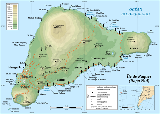
This image was selected as picture of the day on Wikimedia Commons for 1 December 2008. It was captioned as follows: English: Detailed topographic map in English of Easter Island. Other languages:
Afrikaans: Gedetaileerde topografie van Paaseiland Català: Mapa topogràfic detallat en anglès de l'Illa de Pasqua. Čeština: Detailní topografická mapa Velikonočního ostrova Eesti: Detailne inglisekeelne topograafiline kaart et:Lihavõttesaarest. English: Detailed topographic map in English of Easter Island. Esperanto: detala topografia mapo de la Paskinsulo (jen anglalingva, sed ankaŭ havebla en pluraj aliaj lingvoj) Français : Carte topographique détaillée en anglais de l'île de Pâques Italiano: Mappa topografica dell'Isola di Pasqua, Cile. Nederlands: Engelstalige gedetailleerde topografische kaart van Paaseiland Português: Mapa topográfico detalhado, em Inglês, da Ilha da Páscoa Română: Hartă topografică detaliată, în limba engleză, a insulei Paștelui. Svenska: Detaljerad topografisk karta på engelska över Påskön. Македонски: Детална топографска карта на Велигденскиот Остров на англиски. Русский: Топографическая карта Острова Пасхи 한국어: 이스터 섬의 지형도. 中文: 复活节岛地形图 中文(繁體): 復活節島地形圖 |
| Ìjúwe |
English: Topographic map in French of Easter Island.
Note: The shaded relief is a raster image embedded in the SVG file. Français : Carte topographique en français de l'île de Pâques. Note : les ombres du relief sont une image bitmap embarquée dans le fichier SVG.
|
||
| Ọjọ́ọdún | November 2006 - October 2008 for the new version (see the release note) | ||
| Orísun |
Own work
|
||
| Olùdá | Eric Gaba (Sting - fr:Sting) | ||
| Ìyọ̀nda (Ìtúnlò fáìlì yìí) |
|
||
| Àwọn àtẹ̀jáde míràn |
Derivative works of this file:
[]
|


![[1]](http://www.waymarker.co.uk/ml/rapanui/map.jpg)
_location_map.svg)
This W3C-unspecified vector image was created with Inkscape .

|
This SVG file contains embedded text that can be translated into your language, using any capable SVG editor, text editor or the SVG Translate tool. For more information see: About translating SVG files. |
Ìwé àṣẹ
Èmi gangan, tó jẹ́ pé èmi ni mo ni ẹ̀tọ́àwòkọ iṣẹ́ yìí, fara mọ́ ọ láti tẹ̀ẹ́jáde lábẹ́ ìwé-àṣẹ ìsàlẹ̀ yìí:
Fáìlì yìí wà lábẹ́ ìwé àṣẹ Creative Commons Ìdálórúkọ-Share Alike 2.5 Gbogbogbò.
- Ẹ ní ààyè:
- láti pín pẹ̀lú ẹlòmíràn – láti ṣàwòkọ, pínkiri àti ṣàgbéká iṣẹ́ náà
- láti túndàpọ̀ – láti mulò mọ́ iṣẹ́ míràn
- Lábẹ́ àwọn àdéhùn wọ̀nyí:
- ìdárúkọ – Ẹ gbọdọ̀ ṣe ọ̀wọ̀ tó yẹ, pèsè ìjápọ̀ sí ìwé-àṣe, kí ẹ sì sọ bóyá ìyípadà wáyé. Ẹ le ṣe èyí lórísi ọ̀nà tó bojúmu, sùgbọ́n tí kò ní dà bii pé oníìwé-àṣe fọwọ́ sí yín tàbí lílò yín.
- share alike – Tó bá ṣe pé ẹ ṣ'àtúndàlú, ṣàyípadà, tàbí ṣ'àgbélé sí iṣẹ́-ọwọ́ náà, ẹ lè ṣe ìgbésíta àfikún yín lábẹ́ ìwé-àṣẹ kannáà tàbí tójọra mọ́ ti àtilẹ̀wa.
Ìtàn fáìlì
Ẹ kan kliki lórí ọjọ́ọdún/àkókò kan láti wo fáìlì ọ̀ún bó ṣe hàn ní àkókò na.
| Ọjọ́ọdún/Àkókò | Àwòrán kékeré | Àwọn ìwọ̀n | Oníṣe | Àríwí | |
|---|---|---|---|---|---|
| lọ́wọ́ | 12:46, 22 Oṣù Kẹrin 2010 | | 1,750 × 1,245 (878 KB) | Naturals | Correction mot: Caleta => Crique |
| 12:39, 22 Oṣù Kẹ̀wá 2008 |  | 1,750 × 1,245 (877 KB) | Sting | + scale | |
| 20:02, 21 Oṣù Kẹ̀wá 2008 |  | 1,750 × 1,245 (876 KB) | Sting | Completely new version using other sources ; new standard colors | |
| 01:14, 30 Oṣù Kẹ̀wá 2007 |  | 1,750 × 1,245 (537 KB) | Sting | Some additional info | |
| 13:52, 2 Oṣù Kẹrin 2007 |  | 1,750 × 1,245 (537 KB) | Sting | Bug fix (display of some layers) | |
| 02:34, 27 Oṣù Kínní 2007 |  | 1,750 × 1,245 (577 KB) | Sting | Colour standard | |
| 22:39, 23 Oṣù Kọkànlá 2006 |  | 1,750 × 1,245 (470 KB) | Sting | Cosmetic text rendering correction | |
| 22:32, 23 Oṣù Kọkànlá 2006 |  | 1,750 × 1,245 (470 KB) | Sting | Last (?) correction (thanks Sodipodi) | |
| 21:53, 23 Oṣù Kọkànlá 2006 |  | 1,750 × 1,245 (432 KB) | Sting | Again (via Sodipodi) | |
| 21:16, 23 Oṣù Kọkànlá 2006 |  | 1,750 × 1,245 (552 KB) | Sting | Again (plain svg) |
Ìlò fáìlì
Kò sí ojúewé tó únlo fáìlì yìí.
Ìlò fáìlì káàkiri
Àwọn wiki míràn wọ̀nyí lo fáìlì yìí:
- Ìlò ní ar.wikipedia.org
- Ìlò ní az.wikipedia.org
- Ìlò ní ba.wikipedia.org
- Ìlò ní be.wikipedia.org
- Ìlò ní ca.wikipedia.org
- Ìlò ní cs.wikipedia.org
- Moai
- Pavel Pavel
- Velikonoční ostrov
- Rano Kau
- Orongo (Velikonoční ostrov)
- Anakena
- Rano Raraku
- Pukao
- Maunga Terevaka
- Poike
- Puna Pau
- Šablona:Velikonoční ostrov
- Jacob Roggeveen
- Katherine Routledge
- Hanga Roa
- Ahu Tongariki
- Ahu Akivi
- Ahu Vai Uri
- Ahu Ko Te Riku
- Ahu Nau Nau
- Maunga Orito
- Rano Aroi
- William Mulloy
- Motu Nui
- Národní park Rapa Nui
- Wikipedista:Pilgrim/Pokusy
- Georg Forster
- Ahu Te Pito Kura
- Rongorongo
- Tahai
- Ahu
- Felipe González Ahedo
- Thor Heyerdahl
- Kuchyně Velikonočního ostrova
- Reimiro
- Jean-Baptiste Dutrou-Bornier
- Ìlò ní eo.wikipedia.org
- Ìlò ní fi.wikipedia.org
- Ìlò ní fr.wikipedia.org
Ìfihàn ìlò míràn púpọ̀ fún fálì yìí.