
Fáìlì:Faroe Islands location map.svg

Size of this PNG preview of this SVG file: 465 × 600 pixels. Àwọn ìgbéhàn míràn: 186 × 240 pixels | 372 × 480 pixels | 595 × 768 pixels | 793 × 1,024 pixels | 1,587 × 2,048 pixels | 775 × 1,000 pixels.
Fáìlì àtìbẹ̀rẹ̀ (faili SVG, pẹ̀lú 775 × 1,000 pixels, ìtòbi faili: 63 KB)
|
|
Fáìlì yìí wá láti Wikimedia Commons. Àròyé láti ojúewé ìjúwe rẹ̀ níbẹ̀ nìyí nísàlẹ̀. |
Àkótán
| Ìjúwe |
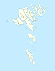
English: Location map of the Faroe Islands
Equirectangular projection, N/S stretching 213 %. Geographic limits of the map:
Deutsch: Positionskarte der Färöer
Quadratische Plattkarte, N-S-Streckung 213 %. Geographische Begrenzung der Karte:
|
| Ọjọ́ọdún | |
| Orísun | Iṣẹ́ onítọ̀hún |
| Olùdá | Erik Frohne |
| Àwọn àtẹ̀jáde míràn |
Derivative works of this file: Strandfaraskip route map.svg Municipalities of the faroe islands 2005.png |
| SVG genesis |
Ìwé àṣẹ
Èmi gangan, tó jẹ́ pé èmi ni mo ni ẹ̀tọ́àwòkọ iṣẹ́ yìí, fara mọ́ ọ láti tẹ̀ẹ́jáde lábẹ́ àwọn ìwé-àṣẹ ìsàlẹ̀ yìí:

|
Ìyọ̀nda wà láti ṣe àwòkọ, láti pínkàkiri àti/tàbí ṣ'àtúnse ìwé yìí l'ábẹ́ àwọn ọ̀rọ̀ àdéhùn GNU Free Documentation License, Version 1.2 tàbí ìtẹ̀jáde ọjọ́ọwájú lát'ọwọ́ Free Software Foundation; láìsí àwọn Ẹsẹ Aláìyàtọ̀, láìsí àwọn Ọ̀rọ̀-ìwé Níwájú, àti láìsí Ọ̀rọ̀-ìwé Lẹ́yìn. Àwòkọ ìwé àṣẹ náà jẹ́ sísopọ̀ mọ́ abala tí àkọlé rẹ̀ jẹ́ GNU Free Documentation License. |
Fáìlì yìí wà lábẹ́ ìwé àṣẹ Creative Commons Ìdálórúkọ-Share Alike 3.0 Aláìkówọlé.
- Ẹ ní ààyè:
- láti pín pẹ̀lú ẹlòmíràn – láti ṣàwòkọ, pínkiri àti ṣàgbéká iṣẹ́ náà
- láti túndàpọ̀ – láti mulò mọ́ iṣẹ́ míràn
- Lábẹ́ àwọn àdéhùn wọ̀nyí:
- ìdárúkọ – Ẹ gbọdọ̀ ṣe ọ̀wọ̀ tó yẹ, pèsè ìjápọ̀ sí ìwé-àṣe, kí ẹ sì sọ bóyá ìyípadà wáyé. Ẹ le ṣe èyí lórísi ọ̀nà tó bojúmu, sùgbọ́n tí kò ní dà bii pé oníìwé-àṣe fọwọ́ sí yín tàbí lílò yín.
- share alike – Tó bá ṣe pé ẹ ṣ'àtúndàlú, ṣàyípadà, tàbí ṣ'àgbélé sí iṣẹ́-ọwọ́ náà, ẹ lè ṣe ìgbésíta àfikún yín lábẹ́ ìwé-àṣẹ kannáà tàbí tójọra mọ́ ti àtilẹ̀wa.
Ẹ le ṣàmúyàn ìwé-àṣẹ tí ó wù yín.
Ìtàn fáìlì
Ẹ kan kliki lórí ọjọ́ọdún/àkókò kan láti wo fáìlì ọ̀ún bó ṣe hàn ní àkókò na.
| Ọjọ́ọdún/Àkókò | Àwòrán kékeré | Àwọn ìwọ̀n | Oníṣe | Àríwí | |
|---|---|---|---|---|---|
| lọ́wọ́ | 13:27, 20 Oṣù Kejìlá 2020 | | 775 × 1,000 (63 KB) | Hanzlan | Húsar merged with Klaksvík |
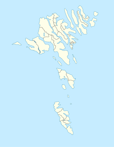
| 12:58, 29 Oṣù Kẹrin 2010 |  | 775 × 1,000 (77 KB) | Erik Frohne | Removal of some borders according to http://www.us.fo/Default.aspx?ID=5497&M=News&PID=6574&NewsID=1842&CATID=29 | |
| 14:46, 7 Oṣù Kẹta 2009 |  | 775 × 1,000 (79 KB) | Erik Frohne | {{Information |Description={{en|1=Location map of the Faroe Islands Equirectangular projection, N/S stretching 213 %. Geographic limits of the map: * N: 62.44° N * S: 61.30° N * W: 7.88° W * E: 6.00° W}} {{de|1=Positionskarte der Färöer Quadra |
Ìlò fáìlì
Ojúewé kan yìí únlo fáìlì yí:
Ìlò fáìlì káàkiri
Àwọn wiki míràn wọ̀nyí lo fáìlì yìí:
- Ìlò ní af.wikipedia.org
- Ìlò ní an.wikipedia.org
- Ìlò ní ar.wikipedia.org
- Ìlò ní ast.wikipedia.org
- Ìlò ní az.wikipedia.org
- Ìlò ní ba.wikipedia.org
- Ìlò ní be-tarask.wikipedia.org
- Ìlò ní be.wikipedia.org
Ìfihàn ìlò míràn púpọ̀ fún fálì yìí.