
Fáìlì:Map of Colorado highlighting Denver County.svg

Size of this PNG preview of this SVG file: 800 × 579 pixels. Àwọn ìgbéhàn míràn: 320 × 232 pixels | 640 × 463 pixels | 1,024 × 741 pixels | 1,280 × 926 pixels | 2,560 × 1,852 pixels | 6,234 × 4,511 pixels.
Fáìlì àtìbẹ̀rẹ̀ (faili SVG, pẹ̀lú 6,234 × 4,511 pixels, ìtòbi faili: 67 KB)
|
|
Fáìlì yìí wá láti Wikimedia Commons. Àròyé láti ojúewé ìjúwe rẹ̀ níbẹ̀ nìyí nísàlẹ̀. |
Àkótán
| Ìjúwe |
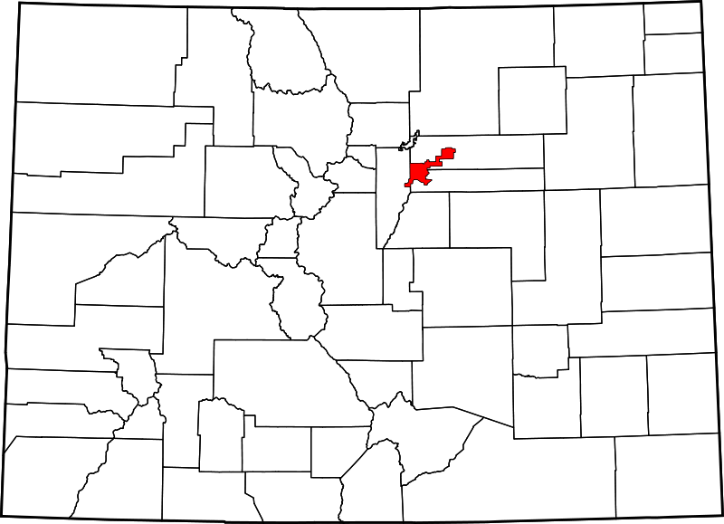
English: A map of Colorado highlighting Denver County. For more information, see Commons:United States county locator maps. |
| Ọjọ́ọdún | |
| Orísun |
Iṣẹ́ onítọ̀hún: English: The maps use data from nationalatlas.gov, specifically countyp020.tar.gz on the Raw Data Download page. The maps also use state outline data from statesp020.tar.gz. The Florida maps use hydrogm020.tar.gz to display Lake Okeechobee. |
| Olùdá | David Benbennick |
Ìwé àṣẹ
| Èmi gangan, tó jẹ́ pé èmi ni mo ni ẹ̀tọ́àwòkọ iṣẹ́ yìí, jọ̀wọ́ ìṣẹ́ yìí sínú ìgboro. Èyí kan gbogbo ayé. In some countries this may not be legally possible; if so: I grant anyone the right to use this work for any purpose, without any conditions, unless such conditions are required by law. |
Ìtàn fáìlì
Ẹ kan kliki lórí ọjọ́ọdún/àkókò kan láti wo fáìlì ọ̀ún bó ṣe hàn ní àkókò na.
| Ọjọ́ọdún/Àkókò | Àwòrán kékeré | Àwọn ìwọ̀n | Oníṣe | Àríwí | |
|---|---|---|---|---|---|
| lọ́wọ́ | 05:42, 13 Oṣù Kejì 2006 | | 6,234 × 4,511 (67 KB) | David Benbennick | New version, smaller file size |
Ìlò fáìlì
Kò sí ojúewé tó únlo fáìlì yìí.
Ìlò fáìlì káàkiri
Àwọn wiki míràn wọ̀nyí lo fáìlì yìí:
- Ìlò ní af.wikipedia.org
- Ìlò ní bpy.wikipedia.org
- Ìlò ní ceb.wikipedia.org
- Ìlò ní en.wikipedia.org
- Denver
- List of counties in Colorado
- Denver International Airport
- LoDo, Denver
- Auraria, Denver
- Alamo Placita, Denver
- Capitol Hill, Denver
- Civic Center, Denver (neighborhood)
- Montbello, Denver
- Washington Park, Denver
- List of people from Denver
- Park Hill, Denver
- Five Points, Denver
- University, Denver
- Cherry Creek, Denver
- Jefferson Park, Denver
- Highland, Denver
- City Park, Denver
- Baker, Denver
- National Register of Historic Places listings in Denver
- Lowry, Denver
- Montclair, Denver
- Sunnyside, Denver
- Berkeley, Denver
- Sun Valley, Denver
- Downtown Denver
- Athmar Park, Denver
- Cheesman Park, Denver
- List of Colorado municipalities by county
- Whittier, Denver
- User:Nyttend/County templates/CO
- Lincoln Park, Denver
- Sloan Lake (Colorado)
- Country Club, Denver
- North Capitol Hill, Denver
- Virginia Village, Denver
- Hampden South, Denver
- Villa Park, Denver
- Globeville, Denver
- City Park West, Denver
- Elyria-Swansea, Denver
- Congress Park, Denver
- Chaffee Park, Denver
- Speer, Denver
- West Colfax, Denver
- Valverde, Denver
- Barnum, Denver
Ìfihàn ìlò míràn púpọ̀ fún fálì yìí.