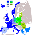
Fáìlì:NATO expansion.png

Ìtóbi ìkọ́yẹ̀wò yìí: 720 × 600 pixels. Àwọn ìgbéhàn míràn: 288 × 240 pixels | 576 × 480 pixels | 922 × 768 pixels | 1,200 × 1,000 pixels.
Fáìlì àtìbẹ̀rẹ̀ (1,200 × 1,000 pixel, ìtóbi faili: 76 KB, irú MIME: image/png)
Ìtàn fáìlì
Ẹ kan kliki lórí ọjọ́ọdún/àkókò kan láti wo fáìlì ọ̀ún bó ṣe hàn ní àkókò na.
| Ọjọ́ọdún/Àkókò | Àwòrán kékeré | Àwọn ìwọ̀n | Oníṣe | Àríwí | |
|---|---|---|---|---|---|
| lọ́wọ́ | 17:25, 3 Oṣù Igbe 2018 |  | 1,200 × 1,000 (76 KB) | Maphobbyist | Reverted to version as of 09:42, 28 February 2009 (UTC) |
| 15:02, 3 Oṣù Igbe 2018 |  | 1,280 × 979 (387 KB) | Maphobbyist | Update: Montenegro became a NATO member in 2017 | |
| 09:42, 28 Oṣù Èrèlé 2009 |  | 1,200 × 1,000 (76 KB) | Turkish Flame~commonswiki | better map | |
| 14:39, 20 Oṣù Ọ̀pẹ̀ 2008 |  | 1,210 × 1,298 (91 KB) | IJA | + Gibraltar. Previously important British Military and Naval bases there, also we have included Spanish enclaves. | |
| 05:40, 5 Oṣù Igbe 2008 |  | 1,210 × 1,298 (91 KB) | Hoshie | fixed Iceland, and the "r" in Turkey | |
| 05:29, 5 Oṣù Igbe 2008 |  | 1,210 × 1,298 (90 KB) | Hoshie | removed anti-aliasing on country labels | |
| 07:19, 18 Oṣù Agẹmọ 2007 |  | 1,210 × 1,298 (97 KB) | Hoshie | The Isle of Man is NOT in the UK! Fixed; under same lic. as original. | |
| 19:33, 25 Oṣù Agẹmọ 2006 |  | 1,210 × 1,298 (97 KB) | Satesclop | +Ceuta and Melilla (in Spain) | |
| 15:24, 14 Oṣù Agẹmọ 2006 |  | 1,210 × 1,298 (97 KB) | Kseferovic | This is the revised edition of the map that includes the Montenegro split from Serbia. (Also someone neglected to put the Bosnian coatline. | |
| 20:16, 25 Oṣù Òkúdu 2006 |  | 1,210 × 1,298 (103 KB) | Kseferovic | This is a revised edition of the map. It has Serbia and Montenegro divided. There are no coyrights. |
Ìlò fáìlì
Kò sí ojúewé tó únlo fáìlì yìí.
Ìlò fáìlì káàkiri
Àwọn wiki míràn wọ̀nyí lo fáìlì yìí:
- Ìlò ní av.wikipedia.org
- Ìlò ní de.wikipedia.org
- Ìlò ní en.wikipedia.org
- Ìlò ní fr.wikipedia.org
- Ìlò ní ru.wikipedia.org
- Ìlò ní uk.wikipedia.org


