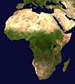
Fáìlì:Africa satellite orthographic.jpg

Ìtóbi ìkọ́yẹ̀wò yìí: 534 × 600 pixels. Àwọn ìgbéhàn míràn: 214 × 240 pixels | 427 × 480 pixels | 684 × 768 pixels | 912 × 1,024 pixels | 1,624 × 1,824 pixels.
Fáìlì àtìbẹ̀rẹ̀ (1,624 × 1,824 pixel, ìtóbi faili: 535 KB, irú MIME: image/jpeg)
Ìtàn fáìlì
Ẹ kan kliki lórí ọjọ́ọdún/àkókò kan láti wo fáìlì ọ̀ún bó ṣe hàn ní àkókò na.
| Ọjọ́ọdún/Àkókò | Àwòrán kékeré | Àwọn ìwọ̀n | Oníṣe | Àríwí | |
|---|---|---|---|---|---|
| lọ́wọ́ | 09:44, 19 Oṣù Kẹrin 2005 |  | 1,624 × 1,824 (535 KB) | Ghalas | A composed satellite photograph of Africa in orthographic projection This is NASA [http://visibleearth.nasa.gov/view_rec.php?vev1id=11656 "Blue Marble"] image applied as a texture on a sphere u |
Ìlò fáìlì
Ojúewé kan yìí únlo fáìlì yí:
Ìlò fáìlì káàkiri
Àwọn wiki míràn wọ̀nyí lo fáìlì yìí:
- Ìlò ní af.wikipedia.org
- Ìlò ní ang.wikipedia.org
- Ìlò ní ar.wikipedia.org
- Ìlò ní ar.wikinews.org
- Ìlò ní ary.wikipedia.org
- Ìlò ní arz.wikipedia.org
- Ìlò ní ast.wikipedia.org
- Ìlò ní as.wikipedia.org
- Ìlò ní awa.wikipedia.org
- Ìlò ní az.wikipedia.org
- Ìlò ní bat-smg.wikipedia.org
- Ìlò ní ba.wikipedia.org
- Ìlò ní be-tarask.wikipedia.org
- Ìlò ní be.wikipedia.org
- Ìlò ní bg.wikipedia.org
Ìfihàn ìlò míràn púpọ̀ fún fálì yìí.


