Jump to content

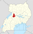
Fáìlì:Masindi District in Uganda.svg

Page contents not supported in other languages.
Lát'ọwọ́ Wikipedia, ìwé ìmọ̀ ọ̀fẹ́

Fáìlì àtìbẹ̀rẹ̀ (faili SVG, pẹ̀lú 1,441 × 1,466 pixels, ìtòbi faili: 368 KB)

Àkótán

Description
English: The location of Masindi District in Uganda, showing district boundaries as they stood in June 2017. For other districts, see Category:SVG locator maps of Districts in Uganda (location map scheme). This map may be incomplete, and may contain errors. Don't rely solely on it for navigation. In particular, note that this map overlays a spherical pseudo-mercator projection on an equirectangular projection; it is far from technically perfect.
 
This W3C-unspecified vector image was created with Inkscape .
Ọjọ́ọdún
Orísun

Derivative of:

Aṣèdá
OpenStreetMap contributors, Jarry1250, NordNordWest
Ìyọ̀nda
(Ìtúnlò fáìlì yìí)
w:en:Creative Commons
ìdárúkọ share alike
Fáìlì yìí wà lábẹ́ ìwé àṣẹ Creative Commons Ìdálórúkọ-Share Alike 3.0 Aláìkówọlé.
Ìdálórúkọ: © OpenStreetMap contributors, Jarry1250, NordNordWest/Wikipedia
Ẹ ní ààyè:
  • láti pín pẹ̀lú ẹlòmíràn – láti ṣàwòkọ, pínkiri àti ṣàgbéká iṣẹ́ náà
  • láti túndàpọ̀ – láti mulò mọ́ iṣẹ́ míràn
Lábẹ́ àwọn àdéhùn wọ̀nyí:
  • ìdárúkọ – Ẹ gbọdọ̀ ṣe ọ̀wọ̀ tó yẹ, pèsè ìjápọ̀ sí ìwé-àṣe, kí ẹ sì sọ bóyá ìyípadà wáyé. Ẹ le ṣe èyí lórísi ọ̀nà tó bojúmu, sùgbọ́n tí kò ní dà bii pé oníìwé-àṣe fọwọ́ sí yín tàbí lílò yín.
  • share alike – Tó bá ṣe pé ẹ ṣ'àtúndàlú, ṣàyípadà, tàbí ṣ'àgbélé sí iṣẹ́-ọwọ́ náà, ẹ lè ṣe ìgbésíta àfikún yín lábẹ́ ìwé-àṣẹ kannáà tàbí tójọra mọ́ ti àtilẹ̀wa.
This work contains information from OpenStreetMap, which is made available under the Open Database License (ODbL).

The ODbL does not require any particular license for maps produced from ODbL data. Prior to 1 August 2020, map tiles produced by the OpenStreetMap Foundation were licensed under the CC-BY-SA-2.0 license. Maps produced by other people may be subject to other licences.

 Geotemporal data
Map location Masindi District, Uganda
Spatial reference system equirectangular
Bounding box
N: 4.5°N
W: 29.2°E E: 35.3°E
S: 1.7°S
Georeferencing Georeference the map in Wikimaps Warper If inappropriate please set warp_status = skip to hide.

akole

Ṣafikun alaye ila kan ti ohun ti faili yii duro

Awọn nkan ṣe afihan ninu faili yii

depicts Èdè Gẹ̀ẹ́sì

copyright status Èdè Gẹ̀ẹ́sì

copyrighted Èdè Gẹ̀ẹ́sì

copyright license Èdè Gẹ̀ẹ́sì

Open Database License Èdè Gẹ̀ẹ́sì

media type Èdè Gẹ̀ẹ́sì

image/svg+xml

data size Èdè Gẹ̀ẹ́sì

376,447 byte

height Èdè Gẹ̀ẹ́sì

1,466 pixel

width Èdè Gẹ̀ẹ́sì

1,441 pixel

checksum Èdè Gẹ̀ẹ́sì

b26e74a97712a2efd1b52c2e8a257d74b2908fd2

Ìtàn fáìlì

Ẹ kan kliki lórí ọjọ́ọdún/àkókò kan láti wo fáìlì ọ̀ún bó ṣe hàn ní àkókò na.

Ọjọ́ọdún/ÀkókòÀwòrán kékeréÀwọn ìwọ̀nOníṣeÀríwí
lọ́wọ́21:06, 25 Oṣù Òkúdu 2017Àwòrán kékeré fún ní 21:06, 25 Oṣù Òkúdu 20171,441 × 1,466 (368 KB)Jarry1250pattypan 17.05

Ojúewé kan yìí únlo fáìlì yí:

Ìlò fáìlì káàkiri

Metadata