
Fáìlì:PIA21100 Severe Air Pollution in New Delhi View by NASA's MISR.jpg

Fáìlì àtìbẹ̀rẹ̀ (3,876 × 3,062 pixel, ìtóbi faili: 1.23 MB, irú MIME: image/jpeg)
|
|
Fáìlì yìí wá láti Wikimedia Commons. Àròyé láti ojúewé ìjúwe rẹ̀ níbẹ̀ nìyí nísàlẹ̀. |
Àkótán
| Ìjúwe |
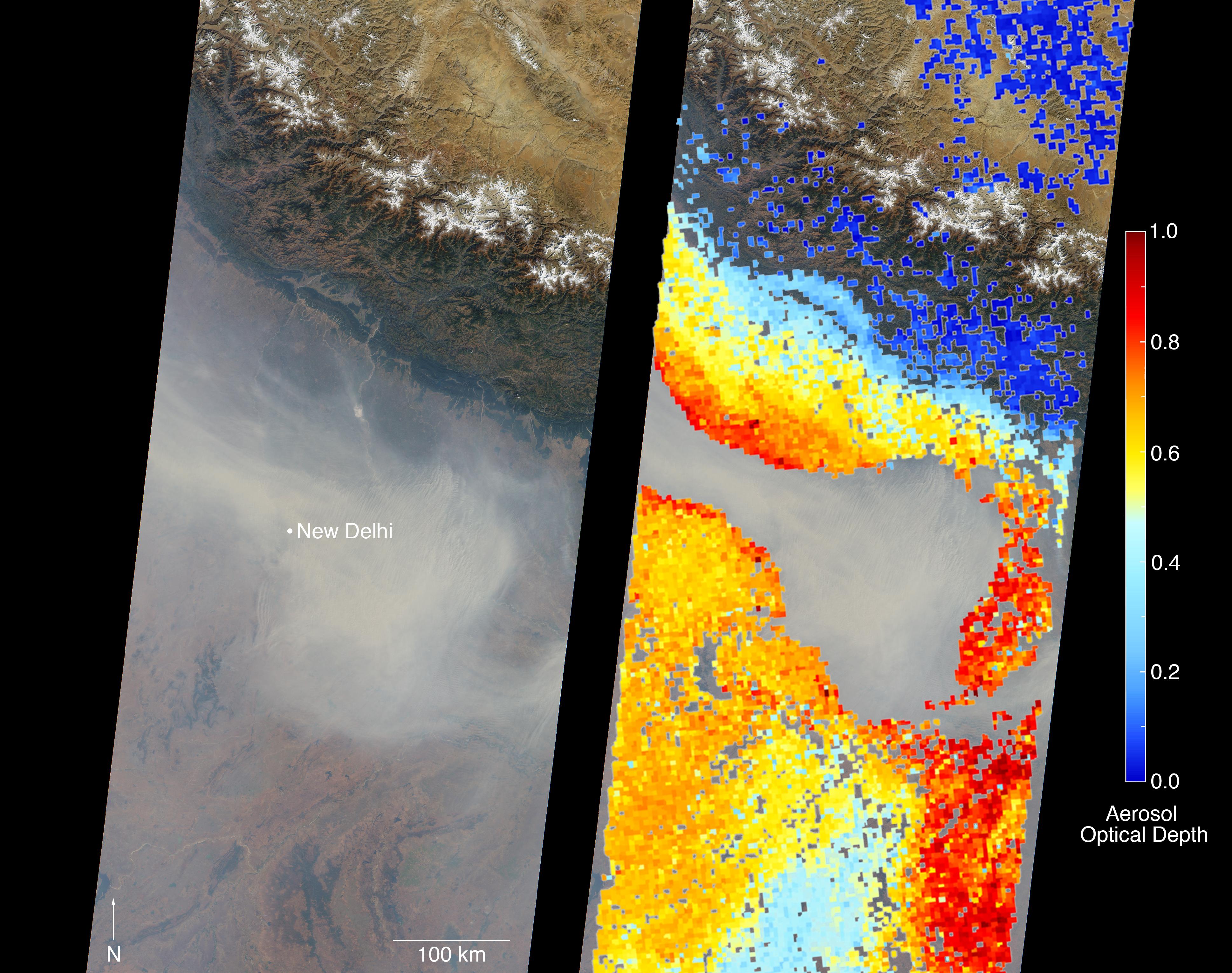
English: New Delhi, India's capital city, is currently suffering though a period of particularly poor air quality. In early November 2016, monitors at various locations in the area posted air quality index measurements as high as the 900s (the most severe ranking, "hazardous," is any air quality index measurement over 300). Thousands of schools have been closed, and a survey by the Associate Chambers of Commerce and Industry of India reports that 10 percent of the city's workers called in sick due to air-pollution-related health issues. According to several published news reports, the extreme air pollution may be due to a combination of nearby agricultural burning after harvest, urban construction and solid-waste burning, as well as remnants of firecracker smoke and additional car emissions after the celebration of Diwali, the Hindu festival of lights, on October 30.
The Multi-angle Imaging SpectroRadiometer (MISR) instrument aboard NASA's Terra satellite passed over the region on Saturday, Nov. 5, 2016, at around 11:05 a.m. local time. At left is an image acquired from MISR's vertical viewing camera. The Himalayas stretch across the northern portion of the image. This towering mountain range tends to concentrate pollution in the region immediately to the south, including New Delhi, by preventing pollutants from blowing northwards. New Delhi, whose location is indicated on the image, is under a patch of especially thick haze. At 6:00 a.m. local time on that date, the U.S. Mission India NowCast Air Quality Index (AQI) for New Delhi was reported at 751, more than twice the threshold for hazardous air quality. At right, a map of aerosol optical depth is superimposed on the image. Optical depth is a quantitative measure of the abundance of aerosols (tiny particles in the atmosphere). Optical depths for the area around New Delhi have not been calculated because the haze is so thick that the algorithm has classified the area as a cloud. In the region immediately surrounding the thick haze, optical depths approach 1.0 (red). An optical depth of 1.0 means that only about 37 percent of direct sunlight reaches the surface due to interactions with particles in the atmosphere. These data were acquired during Terra orbit 89805. Other MISR data are available through the NASA Langley Research Center; for more information, go to https://eosweb.larc.nasa.gov/project/misr/misr_table. MISR was built and is managed by NASA's Jet Propulsion Laboratory, Pasadena, California, for NASA's Science Mission Directorate, Washington, D.C. The Terra spacecraft is managed by NASA's Goddard Space Flight Center, Greenbelt, Maryland. The MISR data were obtained from the NASA Langley Research Center Atmospheric Science Data Center, Hampton, Virginia. JPL is a division of the California Institute of Technology in Pasadena. MISR was built and is managed by NASA's Jet Propulsion Laboratory, Pasadena, California, for NASA's Science Mission Directorate, Washington, D.C. The Terra spacecraft is managed by NASA's Goddard Space Flight Center, Greenbelt, Maryland. The MISR data were obtained from the NASA Langley Research Center Atmospheric Science Data Center, Hampton, Virginia. JPL is a division of Caltech in Pasadena. |
| Ọjọ́ọdún | (published 16 Oṣù Kọkànlá 2016) |
| Orísun | Catalog page · Full-res (JPEG · TIFF) |
| Olùdá | NASA/GSFC/LaRC/JPL, MISR Team |
| Camera location | | View this and other nearby images on: OpenStreetMap |
|---|
This image or video was catalogued by Jet Propulsion Laboratory of the United States National Aeronautics and Space Administration (NASA) under Photo ID: PIA21100. This tag does not indicate the copyright status of the attached work. A normal copyright tag is still required. See Commons:Licensing. Other languages:
|
| This media is a product of the Terra mission Credit and attribution belongs to the Multi-angle Imaging SpectroRadiometer (MISR) team, NASA/GSFC/LaRC/JPL |
Ìwé àṣẹ
| This file is in the public domain in the United States because it was solely created by NASA. NASA copyright policy states that "NASA material is not protected by copyright unless noted". (See Template:PD-USGov, NASA copyright policy page or JPL Image Use Policy.) | ||
 |
Warnings:
|
Ìtàn fáìlì
Ẹ kan kliki lórí ọjọ́ọdún/àkókò kan láti wo fáìlì ọ̀ún bó ṣe hàn ní àkókò na.
| Ọjọ́ọdún/Àkókò | Àwòrán kékeré | Àwọn ìwọ̀n | Oníṣe | Àríwí | |
|---|---|---|---|---|---|
| lọ́wọ́ | 03:56, 5 Oṣù Kẹta 2017 | | 3,876 × 3,062 (1.23 MB) | PhilipTerryGraham | User created page with UploadWizard |
Ìlò fáìlì
Ojúewé kan yìí únlo fáìlì yí:
Ìlò fáìlì káàkiri
Àwọn wiki míràn wọ̀nyí lo fáìlì yìí:
- Ìlò ní bh.wikipedia.org
- Ìlò ní en.wikipedia.org
- Ìlò ní incubator.wikimedia.org