
Fáìlì:Tanezrouft-Reggane(1990).jpg

Ìtóbi ìkọ́yẹ̀wò yìí: 800 × 451 pixels. Àwọn ìgbéhàn míràn: 320 × 180 pixels | 640 × 361 pixels | 1,024 × 577 pixels | 1,280 × 721 pixels | 2,210 × 1,245 pixels.
Fáìlì àtìbẹ̀rẹ̀ (2,210 × 1,245 pixel, ìtóbi faili: 612 KB, irú MIME: image/jpeg)
|
|
Fáìlì yìí wá láti Wikimedia Commons. Àròyé láti ojúewé ìjúwe rẹ̀ níbẹ̀ nìyí nísàlẹ̀. |
.jpg)
Àkótán
| Camera location | | View this and other nearby images on: OpenStreetMap |
|---|
.jpg¶ms=026.622294_N_0000.200859_E_globe:Earth_type:camera__&language=yo)
| Ìjúwe |
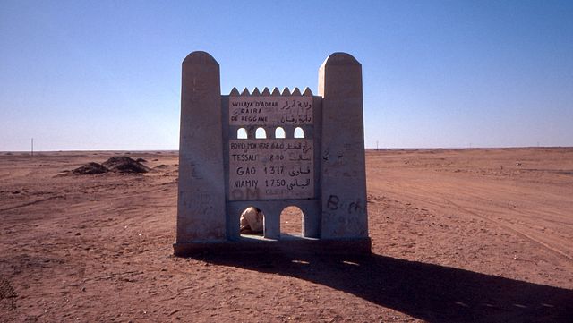
Deutsch: Beginn der Tanezrouft-Piste südlich von Reggane, Algerien
English: Begin of the Tanezrouft road south of Reggane, Algeria |
| Ọjọ́ọdún | Taken on 1 Oṣù Kejì 1990 |
| Orísun | Self-photographed |
| Olùdá | Albert Backer |
Ìwé àṣẹ
Èmi gangan, tó jẹ́ pé èmi ni mo ni ẹ̀tọ́àwòkọ iṣẹ́ yìí, fara mọ́ ọ láti tẹ̀ẹ́jáde lábẹ́ ìwé-àṣẹ ìsàlẹ̀ yìí:
Fáìlì yìí wà lábẹ́ ìwé àṣẹ Creative Commons Ìdálórúkọ-Share Alike 3.0 Aláìkówọlé.
- Ẹ ní ààyè:
- láti pín pẹ̀lú ẹlòmíràn – láti ṣàwòkọ, pínkiri àti ṣàgbéká iṣẹ́ náà
- láti túndàpọ̀ – láti mulò mọ́ iṣẹ́ míràn
- Lábẹ́ àwọn àdéhùn wọ̀nyí:
- ìdárúkọ – Ẹ gbọdọ̀ ṣe ọ̀wọ̀ tó yẹ, pèsè ìjápọ̀ sí ìwé-àṣe, kí ẹ sì sọ bóyá ìyípadà wáyé. Ẹ le ṣe èyí lórísi ọ̀nà tó bojúmu, sùgbọ́n tí kò ní dà bii pé oníìwé-àṣe fọwọ́ sí yín tàbí lílò yín.
- share alike – Tó bá ṣe pé ẹ ṣ'àtúndàlú, ṣàyípadà, tàbí ṣ'àgbélé sí iṣẹ́-ọwọ́ náà, ẹ lè ṣe ìgbésíta àfikún yín lábẹ́ ìwé-àṣẹ kannáà tàbí tójọra mọ́ ti àtilẹ̀wa.
|
According to article 50 of the Algerian copyright law, it shall be lawful to reproduce or to communicate to the public, without authorization of the author and without remuneration, a work of architecture or the fine arts, a work of applied arts or a photographic work that is permanently situated in a public place, with the exception of art galleries, museums and classified cultural or natural sites.
See COM:CRT/Algeria#Freedom of panorama for more information.
|
Ìtàn fáìlì
Ẹ kan kliki lórí ọjọ́ọdún/àkókò kan láti wo fáìlì ọ̀ún bó ṣe hàn ní àkókò na.
| Ọjọ́ọdún/Àkókò | Àwòrán kékeré | Àwọn ìwọ̀n | Oníṣe | Àríwí | |
|---|---|---|---|---|---|
| lọ́wọ́ | 21:25, 26 Oṣù Kínní 2012 | | 2,210 × 1,245 (612 KB) | FatAlbert |
Ìlò fáìlì
Ojúewé kan yìí únlo fáìlì yí:
Ìlò fáìlì káàkiri
Àwọn wiki míràn wọ̀nyí lo fáìlì yìí:
- Ìlò ní arz.wikipedia.org
- Ìlò ní azb.wikipedia.org
- Ìlò ní az.wikipedia.org
- Ìlò ní ceb.wikipedia.org
- Ìlò ní de.wikipedia.org
- Ìlò ní el.wikipedia.org
- Ìlò ní en.wikipedia.org
- Ìlò ní en.wikivoyage.org
- Ìlò ní es.wikipedia.org
- Ìlò ní fa.wikipedia.org
- Ìlò ní fr.wikipedia.org
- Ìlò ní gl.wikipedia.org
- Ìlò ní ha.wikipedia.org
- Ìlò ní hy.wikipedia.org
- Ìlò ní ig.wikipedia.org
- Ìlò ní it.wikipedia.org
- Ìlò ní it.wikivoyage.org
- Ìlò ní kab.wikipedia.org
- Ìlò ní lt.wikipedia.org
- Ìlò ní no.wikipedia.org
- Ìlò ní pt.wikipedia.org
- Ìlò ní ro.wikipedia.org
- Ìlò ní sv.wikipedia.org
- Ìlò ní sw.wikipedia.org
- Ìlò ní ts.wikipedia.org
- Ìlò ní tum.wikipedia.org
- Ìlò ní uk.wikipedia.org
- Ìlò ní ur.wikipedia.org
- Ìlò ní vi.wikipedia.org
- Ìlò ní www.wikidata.org
- Ìlò ní zh.wikipedia.org
- Ìlò ní zh.wikivoyage.org
- Ìlò ní zu.wikipedia.org
.jpg)