
Fáìlì:Tillaberi arrondissements.png
Ìtóbi ìkọ́yẹ̀wò yìí: 738 × 599 pixels. Àwọn ìgbéhàn míràn: 296 × 240 pixels | 591 × 480 pixels | 948 × 770 pixels.
Fáìlì àtìbẹ̀rẹ̀ (948 × 770 pixel, ìtóbi faili: 13 KB, irú MIME: image/png)
|
|
Fáìlì yìí wá láti Wikimedia Commons. Àròyé láti ojúewé ìjúwe rẹ̀ níbẹ̀ nìyí nísàlẹ̀. |
Àkótán
| Ìjúwe |
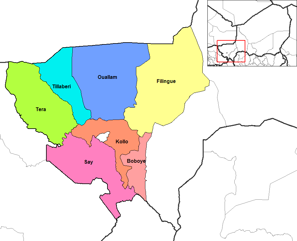
English: Map of the arrondissements of Tillaberi department in Niger. |
| Ọjọ́ọdún | |
| Orísun | Created by Rarelibra 18:44, 13 September 2006 (UTC) for public domain use, using MapInfo Professional v8.5 and various mapping resources. |
| Olùdá | Rarelibra at Èdè Gẹ̀ẹ́sì Wikipédìà |
| Àwọn àtẹ̀jáde míràn | Derivative works of this file: Tillaberi Arrondissements.png |
Ìwé àṣẹ
| This work has been released into the public domain by its author, Rarelibra at Èdè Gẹ̀ẹ́sì Wikipédìà. This applies worldwide. In some countries this may not be legally possible; if so: Rarelibra grants anyone the right to use this work for any purpose, without any conditions, unless such conditions are required by law. |
Original upload log
The original description page was here. All following user names refer to en.wikipedia.
- 2006-09-13 18:44 Rarelibra 1056×816×8 (27966 bytes) Map of the arrondissements of Tillaberi department in Niger. Created by ~~~~ for public domain use, using MapInfo Professional v8.5 and various mapping resources.
Ìtàn fáìlì
Ẹ kan kliki lórí ọjọ́ọdún/àkókò kan láti wo fáìlì ọ̀ún bó ṣe hàn ní àkókò na.
| Ọjọ́ọdún/Àkókò | Àwòrán kékeré | Àwọn ìwọ̀n | Oníṣe | Àríwí | |
|---|---|---|---|---|---|
| lọ́wọ́ | 23:23, 11 Oṣù Kẹ̀wá 2018 | | 948 × 770 (13 KB) | Ras67 | cropped and optimized |
| 14:11, 6 Oṣù Kínní 2008 |  | 1,056 × 816 (27 KB) | Tomia | full resolution from en: | |
| 19:03, 16 Oṣù Kejì 2007 |  | 776 × 600 (92 KB) | Reyos | from http://en.wikipedia.org/wiki/Image:Tillaberi_arrondissements.png |
Ìlò fáìlì
Ojúewé kan yìí únlo fáìlì yí:
Ìlò fáìlì káàkiri
Àwọn wiki míràn wọ̀nyí lo fáìlì yìí:
- Ìlò ní ar.wikipedia.org
- Ìlò ní de.wikipedia.org
- Ìlò ní en.wikipedia.org
- Ìlò ní es.wikipedia.org
- Ìlò ní fa.wikipedia.org
- Ìlò ní fi.wikipedia.org
- Ìlò ní frr.wikipedia.org
- Ìlò ní fr.wikipedia.org
Ìfihàn ìlò míràn púpọ̀ fún fálì yìí.