
Fáìlì:WTOmap currentmemberYN.png

Ìtóbi ìkọ́yẹ̀wò yìí: 800 × 370 pixels. Àwọn ìgbéhàn míràn: 320 × 148 pixels | 640 × 296 pixels | 1,357 × 628 pixels.
Fáìlì àtìbẹ̀rẹ̀ (1,357 × 628 pixel, ìtóbi faili: 32 KB, irú MIME: image/png)
|
|
Fáìlì yìí wá láti Wikimedia Commons. Àròyé láti ojúewé ìjúwe rẹ̀ níbẹ̀ nìyí nísàlẹ̀. |
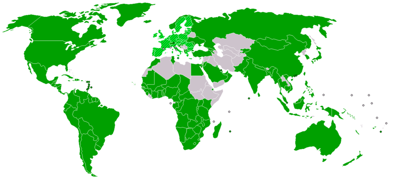
| Ìjúwe | World map of World Trade Organization (WTO) members/non-members, 2005; | ||
| Ọjọ́ọdún | |||
| Orísun |
based on Image:BlankMap-World-v2.png Activity information comes from wto.org:
|
||
| Olùdá |
|
||
| Ìyọ̀nda (Ìtúnlò fáìlì yìí) |
|


|
File:WTOmap currentmember.svg is a vector version of this file. It should be used in place of this PNG file when not inferior.
File:WTOmap currentmemberYN.png → File:WTOmap currentmember.svg
For more information, see Help:SVG. |
 |
Ìtàn fáìlì
Ẹ kan kliki lórí ọjọ́ọdún/àkókò kan láti wo fáìlì ọ̀ún bó ṣe hàn ní àkókò na.
| Ọjọ́ọdún/Àkókò | Àwòrán kékeré | Àwọn ìwọ̀n | Oníṣe | Àríwí | |
|---|---|---|---|---|---|
| lọ́wọ́ | 11:31, 22 Oṣù Kẹjọ 2012 | | 1,357 × 628 (32 KB) | PICAWN | Reverted to version as of 11:25, 22 August 2012 |
| 11:29, 22 Oṣù Kẹjọ 2012 |  | 1,357 × 628 (32 KB) | PICAWN | Sorry, previous was unsaved version | |
| 11:25, 22 Oṣù Kẹjọ 2012 |  | 1,357 × 628 (32 KB) | PICAWN | Added Russia per http://en.ria.ru/papers/20120822/175363528.html | |
| 12:50, 9 Oṣù Keje 2011 |  | 1,357 × 628 (55 KB) | Maphobbyist | South Sudan has become independent on July 9, 2011. Sudan and South Sudan are shown with the new international border between them. | |
| 20:27, 19 Oṣù Kọkànlá 2008 |  | 1,357 × 628 (28 KB) | Mareklug | white -> transparent. These maps are used in navboxes where the background seldom matches white. the background (sea) needs to be tranparent so that such usage does not look bad. | |
| 03:08, 24 Oṣù Kẹfà 2008 |  | 1,357 × 628 (20 KB) | Waldyrious | +Cape Verde | |
| 08:16, 30 Oṣù Kẹrin 2008 |  | 1,357 × 628 (19 KB) | Ekeb | Reverted to version as of 20:20, 5 February 2008 | |
| 18:29, 6 Oṣù Kẹta 2008 |  | 1,357 × 628 (15 KB) | SeNeKa~commonswiki | Reverted to version as of 03:24, 5 October 2007 | |
| 20:20, 5 Oṣù Kejì 2008 |  | 1,357 × 628 (19 KB) | Sasha Krotov | +Ukraine + Moldavia | |
| 03:24, 5 Oṣù Kẹ̀wá 2007 |  | 1,357 × 628 (15 KB) | Tene~commonswiki | Optimised with PNGOUT (0;r) |
Ìlò fáìlì
Kò sí ojúewé tó únlo fáìlì yìí.
Ìlò fáìlì káàkiri
Àwọn wiki míràn wọ̀nyí lo fáìlì yìí:
- Ìlò ní fr.wikipedia.org
- Ìlò ní ka.wikipedia.org
- საქართველოს ეკონომიკა
- მსოფლიო სავაჭრო ორგანიზაცია
- თარგი:მსოფლიო სავაჭრო ორგანიზაცია
- ლიეტუვის ეკონომიკა
- ჩილეს ეკონომიკა
- პოლონეთის ეკონომიკა
- მოზამბიკის ეკონომიკა
- ლუქსემბურგის ეკონომიკა
- იემენის ეკონომიკა
- ალბანეთის ეკონომიკა
- იაპონიის ეკონომიკა
- კამბოჯის ეკონომიკა
- ტაილანდის ეკონომიკა
- მაკაოს ეკონომიკა
- ტაივანის ეკონომიკა
- ვიეტნამის ეკონომიკა
- ჰონგ-კონგის ეკონომიკა
- ინდონეზიის ეკონომიკა
- ირანის ეკონომიკა
- იორდანიის ეკონომიკა
- ისრაელის ეკონომიკა
- კატარის ეკონომიკა
- ბანგლადეშის ეკონომიკა
- ავღანეთის ეკონომიკა
- არაბთა გაერთიანებული საამიროების ეკონომიკა
- ბაჰრეინის ეკონომიკა
- ბრუნეის ეკონომიკა
- მალაიზიის ეკონომიკა
- მონღოლეთის ეკონომიკა
- ნეპალის ეკონომიკა
- სამხრეთ კორეის ეკონომიკა
- ომანის ეკონომიკა
- ჩინეთის ეკონომიკა
- სინგაპურის ეკონომიკა
- პაკისტანის ეკონომიკა
- ქუვეითის ეკონომიკა
- საუდის არაბეთის ეკონომიკა
- სომხეთის ეკონომიკა
- კვიპროსის ეკონომიკა