
Fáìlì:WestAfrica1625.png
Kò sí ìgbéhàn gíga jù báun lọ.
WestAfrica1625.png (498 × 306 pixel, ìtóbi faili: 31 KB, irú MIME: image/png)
|
|
Fáìlì yìí wá láti Wikimedia Commons. Àròyé láti ojúewé ìjúwe rẹ̀ níbẹ̀ nìyí nísàlẹ̀. |

|
This historical map image could be re-created using vector graphics as an SVG file. This has several advantages; see Commons:Media for cleanup for more information. If an SVG form of this image is available, please upload it and afterwards replace this template with
{{vector version available|new image name}}.
It is recommended to name the SVG file “WestAfrica1625.svg”—then the template Vector version available (or Vva) does not need the new image name parameter. |
Àkótán
| Ìjúwe |
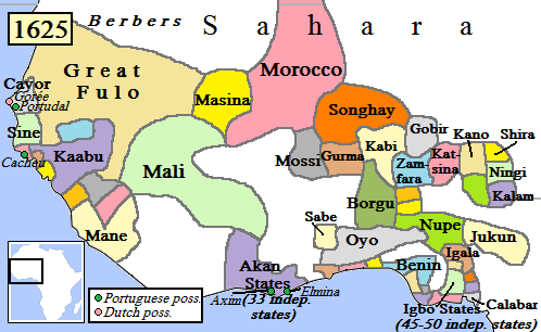
English: Map of West Africa, AD 1625.
(Partially based on Atlas of World History (2007) - Early modern Africa, map.) |
| Ọjọ́ọdún | |
| Orísun | Iṣẹ́ onítọ̀hún |
| Olùdá | Gabagool |
Ìwé àṣẹ
Èmi gangan, tó jẹ́ pé èmi ni mo ni ẹ̀tọ́àwòkọ iṣẹ́ yìí, fara mọ́ ọ láti tẹ̀ẹ́jáde lábẹ́ ìwé-àṣẹ ìsàlẹ̀ yìí:
Fáìlì yìí wà lábẹ́ ìwé àṣẹ Creative Commons Ìdálórúkọ 3.0 Aláìkówọlé.
- Ẹ ní ààyè:
- láti pín pẹ̀lú ẹlòmíràn – láti ṣàwòkọ, pínkiri àti ṣàgbéká iṣẹ́ náà
- láti túndàpọ̀ – láti mulò mọ́ iṣẹ́ míràn
- Lábẹ́ àwọn àdéhùn wọ̀nyí:
- ìdárúkọ – Ẹ gbọdọ̀ ṣe ọ̀wọ̀ tó yẹ, pèsè ìjápọ̀ sí ìwé-àṣe, kí ẹ sì sọ bóyá ìyípadà wáyé. Ẹ le ṣe èyí lórísi ọ̀nà tó bojúmu, sùgbọ́n tí kò ní dà bii pé oníìwé-àṣe fọwọ́ sí yín tàbí lílò yín.
Ìtàn fáìlì
Ẹ kan kliki lórí ọjọ́ọdún/àkókò kan láti wo fáìlì ọ̀ún bó ṣe hàn ní àkókò na.
| Ọjọ́ọdún/Àkókò | Àwòrán kékeré | Àwọn ìwọ̀n | Oníṣe | Àríwí | |
|---|---|---|---|---|---|
| lọ́wọ́ | 17:42, 5 Oṣù Kàrún 2010 | | 498 × 306 (31 KB) | Omar-Toons | Reverted to version as of 00:15, 16 June 2009 |
| 18:05, 20 Oṣù Kẹrin 2010 |  | 497 × 306 (31 KB) | Bokpasa | Saadi dynasty and Tuaregs | |
| 00:15, 16 Oṣù Kẹfà 2009 |  | 498 × 306 (31 KB) | Gabagool | rm lines | |
| 19:57, 19 Oṣù Kẹrin 2009 |  | 498 × 306 (32 KB) | Gabagool | {{Information |Description={{en|1=Map of West Africa, AD 1625. (Partially based on ''Atlas of World History'' (2007) - Early modern Africa, map.)}} |Source=Own work by uploader |Author=Gabagool |Date=2009-04-19 |Permission= |other_versi |
Ìlò fáìlì
Ojúewé kan yìí únlo fáìlì yí:
Ìlò fáìlì káàkiri
Àwọn wiki míràn wọ̀nyí lo fáìlì yìí:
- Ìlò ní af.wikipedia.org
- Ìlò ní als.wikipedia.org
- Ìlò ní ar.wikipedia.org
- Ìlò ní azb.wikipedia.org
- Ìlò ní bn.wikipedia.org
- Ìlò ní ca.wikipedia.org
- Ìlò ní da.wikipedia.org
- Ìlò ní de.wikipedia.org
- Ìlò ní en.wikipedia.org
- Mali Empire
- Songhai Empire
- Songhai people
- Sahelian kingdoms
- Oyo Empire
- History of West Africa
- Islamization of the Sudan region
- Kaabu
- Empire of Great Fulo
- Dendi (province)
- Legends of Africa
- Timeline of Nigerian history
- List of kingdoms in Africa throughout history
- Military history of the Mali Empire
- Nigerian traditional rulers
- User:OnBeyondZebrax/sandbox/African history
- User:Tisquesusa/sandbox9
- The Songhai
- Medieval and early modern Africa
- Ìlò ní en.wikibooks.org
Ìfihàn ìlò míràn púpọ̀ fún fálì yìí.