
Fáìlì:Oxford Centre for Islamic Studies - geograph.org.uk - 1399605.jpg

Ìtóbi ìkọ́yẹ̀wò yìí: 598 × 600 pixels. Àwọn ìgbéhàn míràn: 239 × 240 pixels | 638 × 640 pixels.
Fáìlì àtìbẹ̀rẹ̀ (638 × 640 pixel, ìtóbi faili: 73 KB, irú MIME: image/jpeg)
|
|
Fáìlì yìí wá láti Wikimedia Commons. Àròyé láti ojúewé ìjúwe rẹ̀ níbẹ̀ nìyí nísàlẹ̀. |
Àkótán
| Ìjúwe |
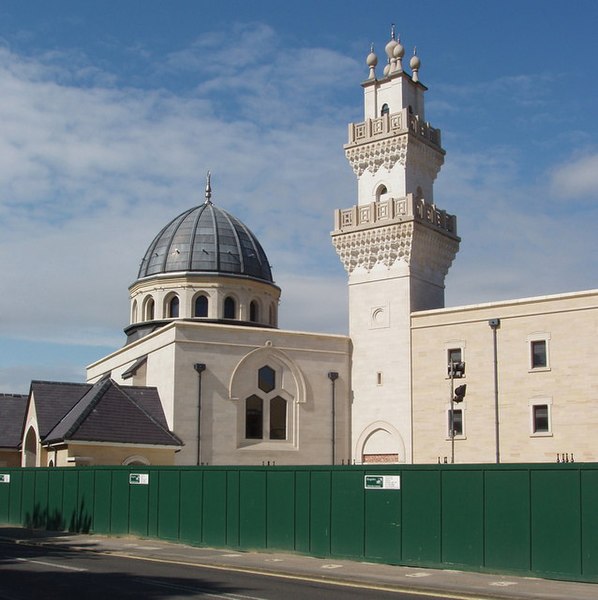
English: Oxford Centre for Islamic Studies (OCIS), Marston Road, Oxford. OCIS was established in 1985 and is a Recognised Independent Centre of the University of Oxford. The photo shows its new building http://www.oxcis.ac.uk/newbuilding.html on the Marston Road, just across the Cherwell from Magdalen College. |
| Ọjọ́ọdún | |
| Orísun | From geograph.org.uk |
| Olùdá | David Hawgood |
| Ìdálórúkọ (required by the license) | David Hawgood / Oxford Centre for Islamic Studies / |
| Camera location | | View this and other nearby images on: OpenStreetMap |
|---|
_heading:270.00&language=yo)
| Object location | | View this and other nearby images on: OpenStreetMap |
|---|
_heading:270.00&language=yo)
Ìwé àṣẹ

|
This image was taken from the Geograph project collection. See this photograph's page on the Geograph website for the photographer's contact details. The copyright on this image is owned by David Hawgood and is licensed for reuse under the Creative Commons Attribution-ShareAlike 2.0 license.
|
Fáìlì yìí wà lábẹ́ ìwé àṣẹ Creative Commons Ìdálórúkọ-Share Alike 2.0 Gbogbogbò.
Ìdálórúkọ: David Hawgood
- Ẹ ní ààyè:
- láti pín pẹ̀lú ẹlòmíràn – láti ṣàwòkọ, pínkiri àti ṣàgbéká iṣẹ́ náà
- láti túndàpọ̀ – láti mulò mọ́ iṣẹ́ míràn
- Lábẹ́ àwọn àdéhùn wọ̀nyí:
- ìdárúkọ – Ẹ gbọdọ̀ ṣe ọ̀wọ̀ tó yẹ, pèsè ìjápọ̀ sí ìwé-àṣe, kí ẹ sì sọ bóyá ìyípadà wáyé. Ẹ le ṣe èyí lórísi ọ̀nà tó bojúmu, sùgbọ́n tí kò ní dà bii pé oníìwé-àṣe fọwọ́ sí yín tàbí lílò yín.
- share alike – Tó bá ṣe pé ẹ ṣ'àtúndàlú, ṣàyípadà, tàbí ṣ'àgbélé sí iṣẹ́-ọwọ́ náà, ẹ lè ṣe ìgbésíta àfikún yín lábẹ́ ìwé-àṣẹ kannáà tàbí tójọra mọ́ ti àtilẹ̀wa.
Ìtàn fáìlì
Ẹ kan kliki lórí ọjọ́ọdún/àkókò kan láti wo fáìlì ọ̀ún bó ṣe hàn ní àkókò na.
| Ọjọ́ọdún/Àkókò | Àwòrán kékeré | Àwọn ìwọ̀n | Oníṣe | Àríwí | |
|---|---|---|---|---|---|
| lọ́wọ́ | 22:41, 28 Oṣù Èrèlé 2011 | | 638 × 640 (73 KB) | GeographBot | == {{int:filedesc}} == {{Information |description={{en|1=Oxford Centre for Islamic Studies The Oxford Centre for Islamic Studies was established in 1985 and is a Recognised Independent Centre of the University of Oxford. The photo shows its new building h |
Ìlò fáìlì
Ojúewé kan yìí únlo fáìlì yí:
Ìlò fáìlì káàkiri
Àwọn wiki míràn wọ̀nyí lo fáìlì yìí:
- Ìlò ní ar.wikipedia.org
- Ìlò ní bn.wikipedia.org
- Ìlò ní en.wikipedia.org
- Ìlò ní fa.wikipedia.org
- Ìlò ní id.wikipedia.org
- Ìlò ní ig.wikipedia.org
- Ìlò ní ms.wikipedia.org
- Ìlò ní sh.wikipedia.org
- Ìlò ní tr.wikipedia.org
- Ìlò ní zh.wikipedia.org