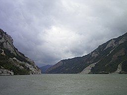
Odò Dánúbì
Ìrísí
(Àtúnjúwe láti Danube river)
| Odò Dánúbì | |
| Àwọn orílẹ̀-èdè | Germany, Austria, Slovakia, Hungary, Moldova, Serbia, Romania, Bulgaria, Croatia, Ukraine |
|---|---|
| Àwọn ìlú | Ulm, Ingolstadt, Regensburg, Passau, Vienna, Bratislava, Budapest, Mohács, Vukovar, Novi Sad, Belgrade, Smederevo, Vidin |
| Primary source | Breg |
| - location | Martinskapelle, Black Forest, Germany |
| - elevation | 1,078 m (3,537 ft) |
| - length | 43 km (27 mi) |
| - coordinates | 48°05′44″N 08°09′18″E / 48.09556°N 8.15500°E |
| Secondary source | Brigach |
| - location | St. Georgen, Black Forest, Germany |
| - elevation | 940 m (3,084 ft) |
| - length | 49 km (30 mi) |
| - coordinates | 48°06′24″N 08°16′51″E / 48.10667°N 8.28083°E |
| Source confluence | |
| - location | Donaueschingen |
| - coordinates | 47°57′03″N 08°31′13″E / 47.95083°N 8.52028°E |
| Mouth | Danube Delta |
| - coordinates | 45°13′3″N 29°45′41″E / 45.21750°N 29.76139°E |
| Length | 2,860 km (1,777 mi) |
| Basin | 817,000 km² (315,445 sq mi) |
| Discharge | for before delta |
| - average | 6,500 m3/s (229,545 cu ft/s) |
Odo Danubi (pípè /ˈdænjuːb/ DAN-ewb tabi Danubi ni soki) ni odo gigunjulo ni Isokan Europe ati odo Europe gigunjulo keji leyin Volga.
Itokasi
[àtúnṣe | àtúnṣe àmìọ̀rọ̀]

|
Àyọkà yìí tàbí apá rẹ̀ únfẹ́ àtúnṣe sí. Ẹ le fẹ̀ jù báyìí lọ tàbí kí ẹ ṣàtúnṣe rẹ̀ lọ́nà tí yíò mu kúnrẹ́rẹ́. Ẹ ran Wikipedia lọ́wọ́ láti fẹ̀ẹ́ jù báyìí lọ. |


