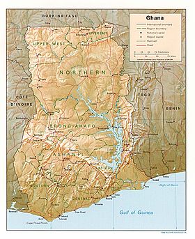
Jẹ́ọ́gráfì ilẹ̀ Ghánà
Ìrísí
(Àtúnjúwe láti Geography of Ghana)

| |
| Continent | Africa |
| Geographic coordinates | 8°00′N 2°00′W / 8.000°N 2.000°W |
| Area - Total - % water |
Ranked 77th 238,540 km² 3.5% (8,520 km²) |
| Coastline | 700 km |
| Highest point | Mount Afadjato, 880 m |
| Lowest point | Atlantic Ocean, 0 m |
| Longest river | Volta River Man Made |
| Largest inland body of water | Lake Volta |
| Land Use - Arable land - Permanent crops - Permanent pastures - Forests and woodlands - Other |
12 % 7 %
22 %
35 % |
| Climate: | Tropical |
| HDI Index | ---- |
| Natural resources | gold, timber, industrial diamonds, bauxite, manganese, fish, rubber, hydropower |
| Environmental issues | drought, deforestation, overgrazing, soil erosion, poaching, habitat destruction, water pollution, drinking water |

Jẹ́ọ́gráfì ilẹ̀ Ghánà

|
Àyọkà yìí tàbí apá rẹ̀ únfẹ́ àtúnṣe sí. Ẹ le fẹ̀ jù báyìí lọ tàbí kí ẹ ṣàtúnṣe rẹ̀ lọ́nà tí yíò mu kúnrẹ́rẹ́. Ẹ ran Wikipedia lọ́wọ́ láti fẹ̀ẹ́ jù báyìí lọ. |
