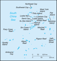
Àwọn Erékùṣù Spratly
Ìrísí
(Àtúnjúwe láti Spratly Islands)
| Disputed islands Other names: see below | |
|---|---|

| |
| Geography | |
| Location | South China Sea |
| Coordinates | 8°38′N 111°55′E / 8.633°N 111.917°ECoordinates: 8°38′N 111°55′E / 8.633°N 111.917°E (Spratly Island) |
| Total islands | over 750 |
| Major islands | Itu Aba Island Namyit Island Northeast Cay Sin Cowe Island Southwest Cay Spratly Island Swallow Reef Thitu Island West York Island |
| Area | less than 5 square kilometres (1.9 sq mi) |
| Coastline | 926 kilometres (575 mi) |
| Highest point | unnamed location on Southwest Cay 4 metres (13 ft) |
| Administered by | |
| Claimed by | |
| EEZ | Louisa Reef |
| State | Sabah |
| Municipality | Kalayaan, Palawan |
| County | Paracels, Spratlys, and Zhongsha Islands Authority, Hainan |
| Municipality | Kaohsiung |
| Province | Khanh Hoa |
| Demographics | |
| Population | No indigenous population[1] |
| Àwọn Erékùṣù Spratly | |||||||||||
|---|---|---|---|---|---|---|---|---|---|---|---|
| Chinese name | |||||||||||
| Traditional Chinese | 南沙群島 | ||||||||||
| Simplified Chinese | 南沙群岛 | ||||||||||
| |||||||||||
| Filipino name | |||||||||||
| Tagalog | Kapuluan ng Kalayaan | ||||||||||
| Malay name | |||||||||||
| Malay | Kepulauan Spratly | ||||||||||
| Vietnamese name | |||||||||||
| Quốc ngữ | Quần Đảo Trường Sa | ||||||||||
| Hán tự | 群島長沙 | ||||||||||
Spratly Islands

|
Àyọkà yìí tàbí apá rẹ̀ únfẹ́ àtúnṣe sí. Ẹ le fẹ̀ jù báyìí lọ tàbí kí ẹ ṣàtúnṣe rẹ̀ lọ́nà tí yíò mu kúnrẹ́rẹ́. Ẹ ran Wikipedia lọ́wọ́ láti fẹ̀ẹ́ jù báyìí lọ. |
Itokasi
[àtúnṣe | àtúnṣe àmìọ̀rọ̀]- ↑ Note: There are scattered garrisons occupied by personnel of several claimant states.CIA World Factbook : Spratley Islands
