Erékùṣù Àjínde
Ìrísí
Easter Island Rapa Nui Isla de Pascua | |
|---|---|
 | |
| Olùìlú | Hanga Roa |
| Àwọn èdè ìṣẹ́ọba | Spanish, Rapa Nui [1] |
| Àwọn ẹ̀yà ènìyàn (2002) | Rapanui 60%, European or mestizo 39%, Amerindian 1% |
| Orúkọ aráàlú | Rapa Nui or Pascuense |
| Ìjọba | Special territory of Chile[2] |
• Provincial Governor | Pedro Pablo Edmunds Paoa |
• Mayor | Luz Zasso Paoa |
| Annexation to Chile | |
• Treaty signed | September 9, 1888 |
| Ìtóbi | |
• Total | 163.6 km2 (63.2 sq mi) |
| Alábùgbé | |
• 2009 estimate | 4,781[3] |
• 2002 census | 3,791 |
• Ìdìmọ́ra | 29.22/km2 (75.7/sq mi) |
| Owóníná | Peso (CLP) |
| Ibi àkókò | UTC-6 (Central Time Zone) |
| Àmì tẹlifóònù | +56 32 |
| Internet TLD | .cl |


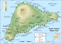
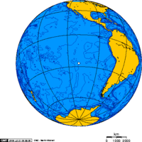
Erekusu Ajinde (Àdàkọ:Lang-rap, Spánì: [Isla de Pascua] error: {{lang}}: text has italic markup (help)) je erekusu ni Polynesia ni apaguusuilaorun Okun Pasifiki, ni ojuami to wa ni apaguusuilaorun julo Polynesian triangle.

| Wikimedia Commons ní àwọn amóunmáwòrán bíbátan mọ́: Easter Island |

|
Àyọkà yìí tàbí apá rẹ̀ únfẹ́ àtúnṣe sí. Ẹ le fẹ̀ jù báyìí lọ tàbí kí ẹ ṣàtúnṣe rẹ̀ lọ́nà tí yíò mu kúnrẹ́rẹ́. Ẹ ran Wikipedia lọ́wọ́ láti fẹ̀ẹ́ jù báyìí lọ. |
Itokasi
[àtúnṣe | àtúnṣe àmìọ̀rọ̀]- ↑ Portal Rapa Nui. http://www.portalrapanui.cl/rapanui/informaciones.htm
- ↑ Pending the enactment of a special charter, the island will continue to be governed as a province of the Valparaíso Region.
- ↑ National Statistics Office (INE).


