Amapá: Ìyàtọ̀ láàrin àwọn àtúnyẹ̀wò
Content deleted Content added
No edit summary |
No edit summary |
||
| Ìlà 1: | Ìlà 1: | ||
{{Infobox state |
|||
<!-- See Template:Infobox settlement for additional fields and descriptions --> |
|||
| name = State of Amapá |
|||
| native_name = |
|||
| native_name_lang = pt<!-- ISO 639-2 code e.g. "fr" for French. --> |
|||
| settlement_type = [[States of Brazil|State]] |
|||
| image_skyline = |
|||
| image_alt = |
|||
| image_caption = |
|||
| image_flag = Bandeira do Amapá.svg |
|||
| flag_alt = |
|||
| image_shield = Brasao amapa.jpg |
|||
| shield_alt = |
|||
| nickname = |
|||
| motto = |
|||
| anthem = |
|||
| image_map = Brazil State Amapa.svg |
|||
| map_alt = |
|||
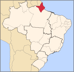
| map_caption = Location of State of Amapá in Brazil |
|||
| latd = 1|latm = 23|latNS = N |
|||
| longd = 51|longm = 49|longEW = W |
|||
| coordinates_type = type:adm1st_region:BR-AP |
|||
| coordinates_display = inline,title |
|||
| coordinates_footnotes = |
|||
| coordinates_region = BR-AP |
|||
| subdivision_type = [[List of sovereign states|Country]] |
|||
| subdivision_name = {{flag|Brazil}} |
|||
| established_title = |
|||
| established_date = |
|||
| founder = |
|||
| seat_type = [[Capital (political)|Capital]] and Largest City |
|||
| seat = [[Macapá]] |
|||
| government_footnotes = |
|||
| leader_party = |
|||
| leader_title = [[Governor (Brazil)|Governor]] |
|||
| leader_name = Camilo Góes Capiberibe |
|||
| leader_title1 = Vice Governor |
|||
| leader_name1 = Dora Nascimento de Souza |
|||
| unit_pref = Metric<!-- or US or UK --> |
|||
| area_footnotes = |
|||
| area_magnitude = 1 E11 |
|||
| area_total_km2 = 142814.585 |
|||
| area_rank = [[List of Brazilian states by area|18th]] |
|||
| elevation_footnotes = |
|||
| elevation_m = |
|||
| population_footnotes = <ref>[http://www.ibge.gov.br/home/presidencia/noticias/noticia_visualiza.php?id_noticia=1766&id_pagina=1 Censo 2010: população do Brasil é de 190.732.694 pessoas]</ref> |
|||
| population_total = 668,689 |
|||
| population_as_of = 2010 census |
|||
| population_est = |
|||
| pop_est_as_of = |
|||
| population_rank = [[List of Brazilian states by population|26th]] |
|||
| population_density_km2 = auto |
|||
| population_density_rank = [[List of Brazilian states by population density|24th]] |
|||
| population_demonym = Amapaense |
|||
| population_note = |
|||
| demographics_type1 = [[Gross domestic product|GDP]] |
|||
| demographics1_footnotes = <!-- for references: use <ref> tags --> |
|||
| demographics1_title1 = Year |
|||
| demographics1_info1 =2006 estimate |
|||
| demographics1_title2 = Total |
|||
| demographics1_info2 = R$ 5,260,000,000 ([[List of Brazilian states by gross domestic product|25th]]) |
|||
| demographics1_title3 = Per capita |
|||
| demographics1_info3 = R$ 8,543 ([[List of Brazilian states by gross domestic product|14th]]) |
|||
| demographics_type2 = [[Human Development Index|HDI]] |
|||
| demographics2_footnotes = <!-- for references: use <ref> tags --> |
|||
| demographics2_title1 = Year |
|||
| demographics2_info1 =2005 |
|||
| demographics2_title2 = Category |
|||
| demographics2_info2 = 0.780 – <span style="color:#fc0">medium</span> ([[List of Brazilian states by Human Development Index|12th]]) |
|||
| timezone1 = [[Time in Brazil|BRT]] |
|||
| utc_offset1 = -3 |
|||
| timezone1_DST = |
|||
| utc_offset1_DST = |
|||
| iso_code = [[ISO 3166-2:BR|BR-AP]] |
|||
| postal_code_type = Postal Code |
|||
| postal_code = 68900-000 to 68999-000 |
|||
| website = |
|||
| footnotes = |
|||
}} |
|||
'''{{PAGENAME}}''' je ikan ninu awon [[States of Brazil|ipinle]] ni orile-ede [[Brasil]]. |
'''{{PAGENAME}}''' je ikan ninu awon [[States of Brazil|ipinle]] ni orile-ede [[Brasil]]. |
||
Àtúnyẹ̀wò ní 10:11, 26 Oṣù Kẹ̀wá 2012
State of Amapá | |||
|---|---|---|---|
| |||
 Location of State of Amapá in Brazil | |||
| Country | |||
| Capital and Largest City | Macapá | ||
| Government | |||
| • Governor | Camilo Góes Capiberibe | ||
| • Vice Governor | Dora Nascimento de Souza | ||
| Area | |||
| • Total | Àdàkọ:Infobox settlement/metric/mag | ||
| Area rank | 18th | ||
| Population (2010 census)[1] | |||
| • Total | 668,689 | ||
| • Rank | 26th | ||
| • Density | 4.7/km2 (12/sq mi) | ||
| • Density rank | 24th | ||
| Demonym(s) | Amapaense | ||
| GDP | |||
| • Year | 2006 estimate | ||
| • Total | R$ 5,260,000,000 (25th) | ||
| • Per capita | R$ 8,543 (14th) | ||
| HDI | |||
| • Year | 2005 | ||
| • Category | 0.780 – medium (12th) | ||
| Time zone | UTC-3 (BRT) | ||
| Postal Code | 68900-000 to 68999-000 | ||
| ISO 3166 code | BR-AP | ||
Amapá je ikan ninu awon ipinle ni orile-ede Brasil.

|
Àyọkà yìí tàbí apá rẹ̀ únfẹ́ àtúnṣe sí. Ẹ le fẹ̀ jù báyìí lọ tàbí kí ẹ ṣàtúnṣe rẹ̀ lọ́nà tí yíò mu kúnrẹ́rẹ́. Ẹ ran Wikipedia lọ́wọ́ láti fẹ̀ẹ́ jù báyìí lọ. |


