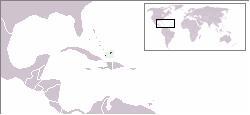
Àwọn Erékùṣù Turks àti Caicos
Ìrísí
Turks and Caicos Islands | |
|---|---|
|
Àsìá | |
Orin ìyìn: "God Save the Queen" | |
 | |
 | |
| Olùìlú | Cockburn Town |
| Ìlú tótóbijùlọ | Providenciales |
| Àwọn èdè ìṣẹ́ọba | English |
| Àwọn ẹ̀yà ènìyàn | 90% Black, 10% Multiracial, European, North American[1] |
| Ìjọba | British Overseas Territory (self-government currently suspended) |
• Queen | Elizabeth II |
• Governor | Gordon Wetherell |
• Premier | Office suspended, powers delegated to governor. [2][3] |
| Ìtóbi | |
• Total | 417 km2 (161 sq mi) (199th) |
• Omi (%) | negligible |
| Alábùgbé | |
• 2008 estimate | 36,605[4] (?) |
• Ìdìmọ́ra | 88/km2 (227.9/sq mi) (n/a) |
| HDI (n/a) | 0.930 very high · n/a |
| Owóníná | U.S. dollar (USD) |
| Ibi àkókò | UTC-5 |
• Ìgbà oru (DST) | UTC-4 |
| Ojúọ̀nà ọkọ́ | left |
| Àmì tẹlifóònù | +1-649 |
| ISO 3166 code | TC |
| Internet TLD | .tc |
Coordinates: 21°30′18″N 71°45′14″W / 21.505°N 71.754°W

|
Àyọkà yìí tàbí apá rẹ̀ únfẹ́ àtúnṣe sí. Ẹ le fẹ̀ jù báyìí lọ tàbí kí ẹ ṣàtúnṣe rẹ̀ lọ́nà tí yíò mu kúnrẹ́rẹ́. Ẹ ran Wikipedia lọ́wọ́ láti fẹ̀ẹ́ jù báyìí lọ. |
Itokasi
[àtúnṣe | àtúnṣe àmìọ̀rọ̀]- ↑ Ben Cahoon. "Worldstatesman Statistics". Worldstatesmen.org. Retrieved 2009-08-15.
- ↑ "UK imposes Turks and Caicos rule". Retrieved 2009-08-14.
- ↑ "Turks and Caicos: Britain suspends government in overseas territory". Retrieved 2009-08-14.
- ↑ "Turks and Caicos Department of Economic Planning and Statistics". Retrieved 2009-07-07.

