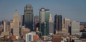
Ìlú Kansas
Ìrísí
Ìlú Kansas
| jé ara | Kansas City metropolitan area |
|---|---|
| ìbèrè | 1853 |
| orúkọ tì íjoba | Kansas City |
| native label | Kansas City |
| orílè-èdè | Àwọn Ìpínlẹ̀ Aṣọ̀kan Amẹ́ríkà |
| olú ìlú fún | Jackson County |
| Ìjoba ìbílè | Jackson County |
| located in time zone | UTC−06:00, Central Time Zone, UTC−05:00 |
| located in the statistical territorial entity | Kansas City metropolitan area |
| territory overlaps | Kansas City urban area |
| coordinate location | 39°3′0″N 94°35′0″W |
| office held by head of government | Mayor of Kansas City, Missouri |
| olorí ìjọba | Quinton Lucas |
| jé ara egbé | Creative Cities Network |
| ẹni tóni | Kansas City International Airport, Hy-Vee Arena, T-Mobile Center, Municipal Stadium, Swope Soccer Village |
| pín ibodè pèlú | North Kansas City |
| official website | https://www.kcmo.gov/ |
| àṣìá | flag of Kansas City, Missouri |
| maintained by WikiProject | WikiProject Kansas City |
| has works in the collection | Print Collection |
| economy of topic | economy of Kansas City |
| time of earliest written record | 1831 |
| local dialing code | 816 |
| category for honorary citizens of entity | Q65609819 |
| category for maps or plans | Category:Maps of Kansas City, Missouri |

Ìlú Kansas je ilu kan ni orile-ede Amerika.

|
Àyọkà yìí tàbí apá rẹ̀ únfẹ́ àtúnṣe sí. Ẹ le fẹ̀ jù báyìí lọ tàbí kí ẹ ṣàtúnṣe rẹ̀ lọ́nà tí yíò mu kúnrẹ́rẹ́. Ẹ ran Wikipedia lọ́wọ́ láti fẹ̀ẹ́ jù báyìí lọ. |

