Gauteng
Ìrísí
Gauteng | |
|---|---|
| The Province of Gauteng | |
| Motto(s): Unity in Diversity | |
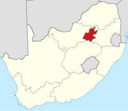
 Location of Gauteng in South Africa | |
| Country | |
| Established | 27 April 1994 |
| Capital | Johannesburg |
| Districts | |
| Government | |
| • Type | Parliamentary system |
| • Premier | Nomvula Mokonyane (ANC) |
| Area | |
| • Total | 17,010 km2 (6,570 sq mi) |
| Area rank | 9th in South Africa |
| Highest elevation | 1,913 m (6,276 ft) |
| Population (2007)[2] | |
| • Total | 10,451,713 |
| • Rank | 1st in South Africa |
| • Density | 610/km2 (1,600/sq mi) |
| • Density rank | 1st in South Africa |
| Population groups | |
| • Black African | 75.2% |
| • White | 18.4% |
| • Coloured | 3.7% |
| • Indian or Asian | 2.7% |
| Languages | |
| • Zulu | 21.1% |
| • Afrikaans | 13.6% |
| • Sotho | 12.6% |
| • English | 12.0% |
| • Northern Sotho | 11.2% |
| Time zone | UTC+2 (SAST) |
| ISO 3166 code | ZA-GT |
| Website | www.gautengonline.gov.za |
Gauteng jẹ́ ọ̀kan lára àwọn ìgbèríko 9 ní orílẹ̀-èdè Gúúsù Áfíríkà.

|
Àyọkà yìí tàbí apá rẹ̀ únfẹ́ àtúnṣe sí. Ẹ le fẹ̀ jù báyìí lọ tàbí kí ẹ ṣàtúnṣe rẹ̀ lọ́nà tí yíò mu kúnrẹ́rẹ́. Ẹ ran Wikipedia lọ́wọ́ láti fẹ̀ẹ́ jù báyìí lọ. |
Àwọn Ìtọ́kasí
[àtúnṣe | àtúnṣe àmìọ̀rọ̀]- ↑ Burger, Delien, ed (2009). "The land and its people". South Africa Yearbook 2008/09. Pretoria: Government Communication & Information System. p. 20. ISBN 978-0-621-38412-3. http://www.gcis.gov.za/resource_centre/sa_info/yearbook/2009/chapter1.pdf. Retrieved 23 September 2009.
- ↑ "Community Survey 2007: Basic results" (PDF). Statistics South Africa. p. 2. Retrieved 23 September 2009.
- ↑ "Statistical release P0301: Community Survey, 2007 (Revised version)" (PDF). Statistics South Africa. p. 25. Retrieved 7 October 2009.
- ↑ "Table: Census 2001 by province, language, population group and gender.". Census 2001 Interactive Tables. Statistics South Africa. Retrieved 28 January 2010.
